
Iceland · 12 April 2026
Iceland's Ring Road in 14 Days: The Complete Route
A detailed 14-day itinerary for Iceland's Ring Road. Stages, distances, essential stops, and planning tips for independent travellers.

The Ring Road is a 1,322-kilometre highway that circles Iceland. Put like that, it sounds modest: a paved loop around a not-very-large island. But that description conceals what the journey actually is — a passage through every geological force that has shaped this planet. Glaciers burying active volcanoes. Lava fields from eruptions that happened yesterday in geological terms. Waterfalls plunging from plateaus where nobody lives. Fjords carved by ice over a hundred thousand years. And threading through all of it, a civilisation that has spent a millennium surviving in a place where the ground never stops moving.
The road was designated Route 1 in 1974, when the final section in the east was completed. Before that, driving around Iceland was a genuine expedition: unbridged rivers, unpaved stretches, passages impassable in winter. Today the Ring Road is paved almost entirely — a few gravel sections remain in the east — and in summer it is perfectly manageable in a standard rental car. But accessible does not mean trivial. The weather shifts without warning, the distances between services can be long, and the temptation to detour toward every waterfall, every crater, every hot spring turns any itinerary into a constant negotiation between the time you have and the things still left to see.
Fourteen days is the right amount of time to do the Ring Road properly. You can manage it in ten, but then you must choose what to sacrifice. With two weeks you can complete the full loop, add the Snaefellsnes peninsula, and give each region enough time so the trip does not become a race between viewpoints.
Days 1-2: Reykjavik and the Reykjanes Peninsula
Base: Reykjavik
Spend the first day in Reykjavik. Not because it has monuments that demand a week, but because the smallest capital in northern Europe has a personality that deserves attention. Hallgrimskirkja, the concrete church that dominates the centre, looks like nothing you have seen before: its facade mimics the basalt columns you will encounter throughout the country. The old harbour, converted into a district of restaurants and museums, retains something of the fishing-town atmosphere that defined the city for centuries. And Harpa, the concert hall on the waterfront, is a geometric glass structure that changes colour with the light — one of the few modern buildings in Iceland that genuinely works as architecture.
On the second day, before starting the Ring Road proper, drive south along the Reykjanes Peninsula. It is a lunar landscape: lava fields draped in moss, fumaroles, the Gunnuhver geothermal area with its columns of steam. Here you will find the Bridge Between Two Continents — a symbolic walkway over the rift between the North American and Eurasian tectonic plates. The peninsula was struck by a series of volcanic eruptions between 2021 and 2024 that altered its geography, and the scars of fresh lava are visible from the road.
Day 2 distance: 80 km (round trip from Reykjavik)
Days 3-4: The Golden Circle and the Accessible Interior
Base: Selfoss or surroundings
The Golden Circle is Iceland’s most popular excursion and therefore its most crowded. But there are reasons for that: within a hundred-kilometre radius, three sites explain the island better than any museum.
Thingvellir is where the tectonic plates visibly separate — you can literally walk between two continents. But its importance goes beyond geology: the Althing was founded here in 930 AD, the parliament that governed Iceland for centuries and remains one of the oldest in the world. The Viking chieftains gathered in this valley not by chance: the natural acoustics of the canyon amplified the voice of the Lawspeaker, who recited the entire legal code from memory.
Geysir is the original geyser, the one that gave its name to every geyser on Earth. It no longer erupts regularly — its neighbour Strokkur handles that every eight minutes — but the geothermal field surrounding it is an open-air geological laboratory: pools of boiling water, mineral deposits in impossible colours, and the sulphur smell that becomes the olfactory soundtrack of the entire trip.
Gullfoss, the golden waterfall, drops in two stages into a crevice in the rock that seems to swallow the river whole. In the 1920s, foreign investors wanted to build a hydroelectric dam here. Sigridur Tomasdottir, daughter of the landowner, threatened to throw herself into the falls and took the case to court. She lost the lawsuit, but the dam was never built. Her fight is considered Iceland’s first act of environmental conservation.
Beyond the three classic stops, the Kerid volcanic crater deserves the fifteen-minute detour: a natural amphitheatre three thousand years old with a turquoise lake at the bottom. And if the day is long, Fludir has a natural thermal pool — the Secret Lagoon — that is everything Blue Lagoon is not: no queues, no inflated price, no theme-park atmosphere.
Day 3 distance: 230 km (circuit from Selfoss)
Days 5-6: The South Coast
Section: Selfoss to Vik to Kirkjubaejarklaustur
The south coast is Iceland at its most dramatic. The road runs between the Atlantic Ocean on one side and the Vatnajokull glaciers on the other, crossing plains of black sand created by thousands of years of volcanic eruptions and glacial floods.
Seljalandsfoss is the waterfall you can walk behind, circling through a natural cave behind the curtain of water. It is spectacular, but come prepared to get soaked. Five hundred metres away, hidden at the end of a short trail between narrowing cliffs, Gljufrabui is a secret waterfall inside a half-closed cave that few people visit because it is not visible from the car park.
Skogafoss, ten kilometres further east, is brute force: sixty metres of vertical drop, a permanent rainbow when the sun is out, and a metal staircase on the side that climbs to the top where the Fimmvorduhals trail begins — one of Iceland’s finest hikes, crossing between two glaciers to reach Thorsmork.
Reynisfjara beach, near Vik, is probably Iceland’s most photographed location: coal-black sand, hexagonal basalt columns, and the Reynisdrangar rock stacks rising from the sea. It is also one of the most dangerous. Atlantic waves arrive without warning and with enough force to drag a person away. Every year there are serious incidents. Do not turn your back on the sea. This is not a figure of speech: it is a literal instruction.
Vik is the southernmost village in Iceland, with three hundred inhabitants and a white church on the hill that has become a symbol of the country. The village lives under the threat of Katla, the volcano beneath the Myrdalsjokull glacier, whose last major eruption was in 1918. The evacuation plans are up to date. The residents know them.
Day 5 distance: 190 km. Day 6: 150 km to Kirkjubaejarklaustur.
Days 7-8: Glaciers and the Jokulsarlon Lagoon
Section: Kirkjubaejarklaustur to Hofn
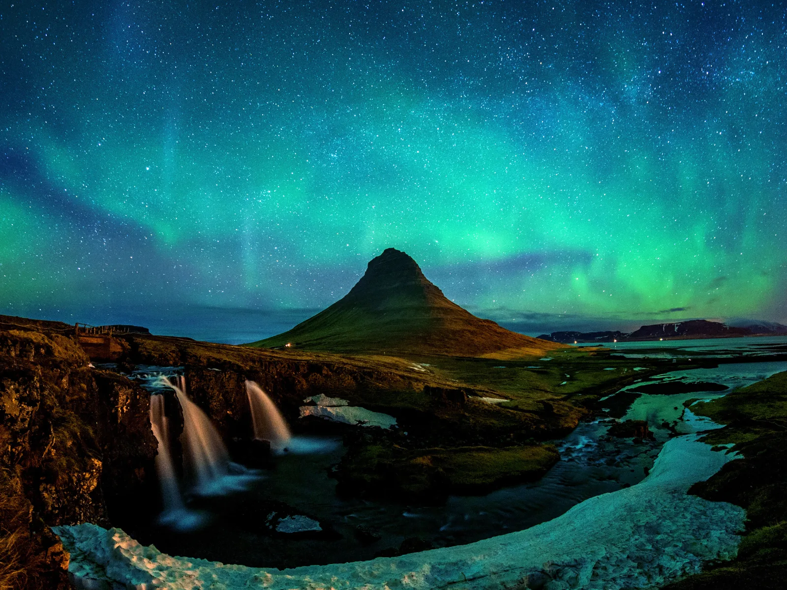
Vatnajokull is the largest glacier in Europe: it covers eight per cent of Iceland and conceals several active volcanoes beneath its ice cap. The road runs parallel to its southern edge, and from it you can see the glacier tongues descending into the valleys like rivers frozen in slow motion.
Skaftafell, within Vatnajokull National Park, is the base for the hike to Svartifoss — a waterfall framed by basalt columns that inspired the design of Hallgrimskirkja. The trail is short (ninety minutes return) but steady in its ascent. From the top, the view of the glacier and the coastal plain is a reminder of the scales Iceland operates at.
Jokulsarlon is the glacial lagoon where icebergs calved from the Breidamerkurjokull glacier float slowly toward the sea. It is a spectacle that did not exist a hundred years ago: the lagoon has formed through the glacier’s retreat, and each year it grows larger. There is something uncomfortable about the beauty of Jokulsarlon, because what you are watching is, quite literally, a glacier dying. The blue and white icebergs drifting in the water are fragments of ice that formed a thousand years ago and will not return.
Diamond Beach, on the other side of the road, is where the smaller icebergs reach the ocean and become stranded on the black sand. The contrast between transparent ice and volcanic sand produces something that looks designed but is pure geology.
Day 7 distance: 130 km. Day 8: 80 km to Hofn, with time for walks.
Days 9-10: The East Fjords
Section: Hofn to Egilsstadir
The East Fjords are the part of Iceland that most travellers cross too quickly. The road becomes more winding, the villages smaller, the tourists less frequent. It is the least visited region on the ring, and precisely for that reason it deserves two days instead of one.
The road follows the coast, dipping in and out of each fjord. Each has its own character. Djupivogur with its fishing harbour and the sculptures of local bird eggs along the dock. Faskrudsfjordur, founded by French fishermen in the nineteenth century, with street signs still bilingual in Icelandic and French. Seydisfjordur, perhaps Iceland’s most beautiful village, at the end of a narrow harbour surrounded by mountains and waterfalls, with its blue church and its artist community.
The rock here is the oldest in the country: rhyolites and basalts fourteen million years old, compared to the lava just weeks old that you saw on Reykjanes. The fjords formed during the Pleistocene glaciations, when glaciers carved the valleys that the sea flooded as the ice retreated. The geology of the east is Iceland’s long memory.
Egilsstadir, the capital of the east, is not picturesque but it is functional: large supermarket, petrol station, hospital. It is a good place to resupply before heading north.
Day 9 distance: 170 km. Day 10: 160 km to Egilsstadir.
Days 11-12: The North — Myvatn, Akureyri, Husavik
Section: Egilsstadir to Akureyri
Northern Iceland has a distinct personality. The climate is drier than in the south, farming is possible in some valleys, and the country’s second city — Akureyri, with its eighteen thousand inhabitants — functions as an alternative cultural capital to Reykjavik.
But before Akureyri comes Lake Myvatn, and Myvatn is one of those places that justifies an entire trip. The lake formed two thousand three hundred years ago from a lava eruption, and since then it has been a unique ecosystem: millions of midges (my means midge in Icelandic), dozens of duck species, and active geology that includes pseudocraters (formed when lava flowed over the lake and steam exploded through it), fumaroles, lava caves, and natural hot springs.
Dimmuborgir, beside the lake, is a labyrinth of lava formations that resemble the ruins of a dark city. Local legend says it is a gateway to hell. Geology says it is what remains when a lava lake cools unevenly and the roof collapses. Both explanations are compatible with how the place looks.
Husavik, on the north coast, is the historic whaling port turned whale-watching capital. The waters of Skjalfandi Bay are regular territory for humpback whales, and the sighting rate in summer exceeds ninety per cent. The Whale Museum, housed in a former slaughterhouse, tells the story of Icelandic whaling without romance but with honesty.
Akureyri deserves an afternoon: the world’s most northerly botanical garden, a church designed by the same architect as Hallgrimskirkja, and a cafe scene that defies the city’s size.
Day 11 distance: 170 km. Day 12: 100 km to Akureyri.
Day 13: The Snaefellsnes Peninsula
Section: Akureyri to Snaefellsnes (via Route 1 and detour)
The longest stage of the trip: three hundred kilometres from Akureyri to the Snaefellsnes Peninsula, but the road is good and the landscape — the farms of the north, the interior valleys, the mountains separating north from west — holds your attention.
Snaefellsnes is often called “Iceland in miniature” because it concentrates in a hundred kilometres what the rest of the country distributes across thousands: a glacier atop a volcano (Snaefellsjokull, the gateway to the centre of the Earth according to Jules Verne), cliffs with puffin colonies, moss-covered lava fields, black sand beaches, a golden sand beach, fishing villages with wooden churches, and a mountain — Kirkjufell — that has become Iceland’s most photographed peak thanks to its perfect conical shape.
The black church at Budir, alone in a lava field facing the glacier, is one of those places that needs no explanation. Two black walls, a cemetery of green grass, and the Atlantic behind it. Arnarstapi and Hellnar, two fishing villages connected by a two-kilometre coastal trail, offer basalt-arch cliffs and seabird nesting sites.
Sleep in Grundarfjordur or Stykkisholmur. The latter is the largest town on the peninsula with a charming harbour and an information centre about Breidafjordur Bay and its countless islands.
Distance: 300 km from Akureyri. Within the peninsula: 100 km circuit.
Day 14: Return to Reykjavik
Section: Snaefellsnes to Reykjavik (170 km, 2.5 hours)
The final day is a relaxed return. The road from Snaefellsnes passes through Borgarfjordur, where you will find the Hraunfossar waterfalls — water emerging directly from a lava field, as though the rock itself were weeping. It is worth a stop. Deildartunguhver, Europe’s most powerful hot spring, is a few minutes away. And Reykholt, a tiny village that was the home of Snorri Sturluson, author of the Prose Edda and the sagas of the Norse kings, one of the most important literary figures of the European Middle Ages. His thirteenth-century thermal bath survives.
You will reach Reykjavik by mid-afternoon. After two weeks of landscapes that make cities feel irrelevant, Reykjavik recovers its charm precisely through contrast: it is small, colourful, human, and has the best food in the country.
Practical Notes for the Ring Road
When to go. June to August for long days (nearly twenty-four hours of light in June) and open roads. September is viable but daylight shrinks fast and some services close. Outside summer, sections of the Ring Road may be closed by snow.
Car. A standard saloon works for the Ring Road in summer. If you want to detour onto the highlands (F-roads), you need a 4x4 — it is both illegal and dangerous to attempt them without one. Rent with gravel and sand insurance. This is not a frivolous expense: the gravel in the east and the wind-blown sand in the south are real.
Petrol. Stations are spaced reasonably but not abundantly. In the east and north, do not let the tank drop below a quarter. All accept card with PIN. Carry zero cash: Iceland runs exclusively on cards.
Accommodation. Book ahead in summer, especially on the south coast and around Myvatn. Guesthouses, converted farms and hostels are the norm outside Reykjavik. Camping is an excellent option: campsites are found across the country and cost between 1,500 and 2,500 ISK per person.
Food. Eating out is expensive. A main course in a restaurant costs 3,000 to 6,000 ISK (20-40 euros). The alternative: shop at Bonus or Kronan (budget supermarkets) and cook in your accommodation. N1 petrol stations have acceptable hot food. The Icelandic hot dog — pylsur — at Baejarins Beztu is a classic for good reason.
Approximate budget. For two people in a rental car, mixing camping and guesthouses, cooking most meals: 350,000-500,000 ISK per week (2,300-3,300 euros). In guesthouses with dinners out: 600,000-800,000 ISK per week.
Speed limits. 90 km/h on open roads, 50 km/h in towns, 30 km/h on gravel. Speed cameras are frequent and fines steep. Iceland is not a country where driving fast makes sense: speed robs you of landscape.
More on Iceland
Keep reading.
Other pieces from the same destination.

Next step
Ready for Iceland?
The guide is for travelling.
Offline maps, itineraries and everything that doesn't fit in an article.
Get the Iceland guide