
Iceland · 28 June 2026
Snæfellsnes: the peninsula Jules Verne immortalised
In Journey to the Centre of the Earth, Professor Lidenbrock enters the Snæfellsjökull volcano. The volcano exists, the glacier too, and the peninsula around them is probably the best day in Iceland off the Ring Road.

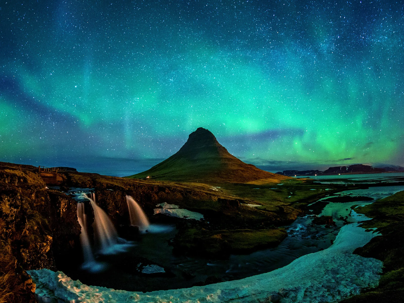
Jules Verne never set foot in Iceland. He wrote Journey to the Centre of the Earth in 1864 from his study in Amiens, working from the accounts of geographers, naturalists and explorers who had mapped the North Atlantic. His choice of Snæfellsjökull as the gateway to the inner world was not random, though. Among all of Iceland’s volcanoes, this one has the most deliberate presence — geometric, almost composed, as if the earth had decided to build something recognisable from the sea. It is a near-perfect cone of 1,446 metres, crowned by a glacier that catches light even on overcast days. From the peninsula’s coast you can see it on the horizon before you understand what you are looking at.
A peninsula in miniature
Snæfellsnes extends ninety kilometres into the Atlantic from western Iceland, pointing roughly towards Greenland. It has exactly the right proportion of everything Iceland promises and rarely concentrates in a single day: black lava fields where moss has spent centuries establishing itself, black sand beaches that absorb rather than reflect light, basalt cliffs where puffins nest from May to August in numbers that verge on the comic. The road that circles the tip of the peninsula — Route 574 — is one of the best drives in the country. Without stops it takes around four hours. With stops, it could fill an entire day.
The village of Arnarstapi, on the southern coast near the tip, offers one of the most unusual geological formations that lava produces when the ocean spends centuries working it over: basalt arches in the sea, hexagonal columns, lava tubes open to the sky. There is not much to do in Arnarstapi beyond walking the coast and looking — which is entirely enough. A few kilometres to the west, Djúpalónssandur is a beach of black rounded boulders where four stones of different weights were used for centuries to test whether a fisherman was strong enough to work the boats. The stones are still there, labelled in Icelandic, alongside the rusted remains of a British trawler that sank in 1948.
Turf churches and what they say
Before timber arrived in Iceland in any quantity, construction was of turf: blocks of compressed earth and grass that insulated well but demanded constant maintenance. The turf churches of Snæfellsnes — including the one at Buðir and the older structure at Ingjaldshóll — represent the most honest architecture the country has ever produced: unpretentious, integrated into the landscape to the point of disappearing into it. Buðir, in particular, has a context that amplifies its effect: a black timber church on a lava field, the ocean behind it, the volcano to the east. It is one of those places that is difficult to photograph without the photograph lying by excess.
The glacier and what it will not always be
Snæfellsjökull National Park, established in 2001, is the only national park in Iceland that includes a coastline. It protects both the glacier and the lava ecosystems, the beaches and the cliffs. The Snæfellsjökull glacier has retreated significantly over the past century. In 2012, glaciologist Oddur Sigurðsson predicted its complete disappearance before 2150 if current trends continue. What has been a geographical constant for millennia may become history within a few generations.
Ascending the glacier is possible with a guide: several operators in Arnarstapi and Grundarfjörður run four-to-six-hour excursions including crampons and ice axe, for around €80 per person. The ascent reaches the summit at 1,446 metres, where the volcanic crater is buried under ice, and on clear days the views stretch to the Westfjords in the north and the south coast towards Reykjavík in the east. The foggy days — frequent here — carry their own kind of value: the glacier’s interior in mist produces a diffuse, white light that looks like nothing else.
For those who prefer not to climb, the view of the volcano from below already justifies the trip. There is a point on Route 574, near Ólafsvík, where on a clear day the cone appears complete above the sea with a precision that seems almost artificial — as if someone had placed an overly perfect stage set.
Getting there and how long to spend
From Reykjavík, the tip of Snæfellsnes is about three hours by car along Route 1 and then Route 54. It works as a long day trip from the capital — leaving early, returning at night — or with one night on the peninsula for more flexibility. Accommodation in Grundarfjörður, Stykkishólmur or near the national park is limited, especially in July and August. Booking at least a month ahead in high season is essential.
The optimal window for puffins is May to mid-August, when the cliffs at Lóndrangar and the Arnarstapi area hold colonies of thousands. For the glacier, any month from June to September works in terms of access, though visibility is always unpredictable. Snæfellsnes makes no promises and offers no guarantees. It gives what it has at the moment you arrive, and that is more than enough.
The complete Far Guides Iceland guide includes detailed routes across the whole island, interactive maps and all the practical information you need to plan your Ring Road and beyond.
More on Iceland
Keep reading.
Other pieces from the same destination.


Next step
Ready for Iceland?
The guide is for travelling.
Offline maps, itineraries and everything that doesn't fit in an article.
Get the Iceland guide