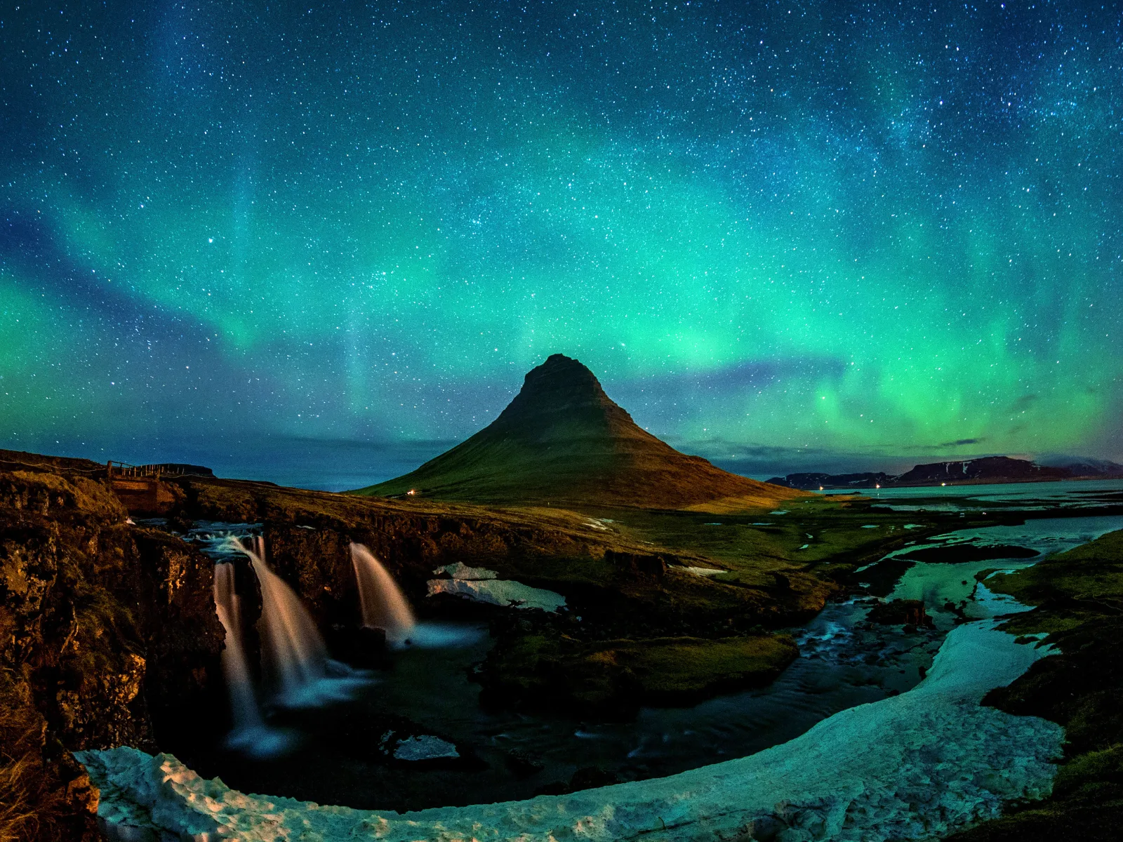

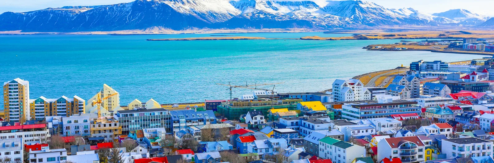
Iceland · 2 May 2026
The Golden Circle: Beyond Geysir and Gullfoss
The Golden Circle is Iceland's most popular route. But there is far more than the three classic stops. A guide to understanding and expanding it.
The Golden Circle is Iceland’s most popular route. Every day, dozens of coaches leave Reykjavik to complete the circuit in eight hours: Thingvellir, Geysir, Gullfoss, return. Three hundred kilometres, three stops, a photograph at each, lunch at a roadside restaurant, back by five. It is a perfect tourism product: compact, spectacular, easy to sell. And for precisely that reason, the way most people experience it does not do it justice.
The problem is not the three sites — all three are extraordinary. The problem is the speed. Thingvellir is not a viewpoint for a photograph: it is the place where geology and democracy intersect in a way that has no equivalent on the planet. Geysir is not a fifteen-minute spectacle: it is a geothermal field that explains the energy powering all of Iceland. And Gullfoss is not simply a large waterfall: it is a story of resistance that changed the country’s relationship with its own nature.
This guide covers the three classic stops with the depth they deserve, then extends the circuit with places the tour buses never visit. The result is a long day or, better still, a day and a half: enough time to understand why this triangle of a hundred kilometres holds so much history, so much geology, and so much beauty.
Thingvellir: Where the World Splits in Two
Thingvellir is forty-five minutes from Reykjavik, and the first thing you see when you arrive is a long valley flanked by walls of rock. It looks like an ordinary landscape until you grasp what you are looking at: those walls are the edges of the North American and Eurasian tectonic plates. The North American plate is to your left, the Eurasian to your right, and the valley between them is widening by two centimetres every year. That is not a metaphor: the earth is physically separating beneath your feet.
The Almannagja rift is the most visible: a basalt canyon stretching several kilometres that you can walk through. The path descends from the visitor centre to the valley floor, passing between walls thirty, forty metres high. Water filtered through porous lava forms small waterfalls inside the rift, and at the end of the trail the parliament plain opens out.
Because Thingvellir is not just geology. Here, in the year 930, Norse settlers founded the Althing: a general assembly where chieftains from across Iceland gathered every summer to make laws, settle disputes, and administer justice. There was no building — there would not be for centuries. Attendees camped in tents along the banks of the Oxara river, and sessions were held in the open at the Logberg (Law Rock), where the logsogumadur (Lawspeaker) recited the current legislation from memory. The entire legal code, every year, from memory. In a society without written law, memory was the institution.
The Althing functioned continuously until 1798, when the Danes dissolved it. It was restored in 1845 and moved to Reykjavik. But Thingvellir remained the symbolic seat of power: the republic was declared here in 1944, before a crowd gathered in the same valley where the first laws had been made a thousand years earlier.
What makes Thingvellir unique is this superposition: a global geological phenomenon — the separation of continents — and an exceptional political phenomenon — one of the world’s oldest parliaments — occurring in the same place. The Vikings chose this valley for practical reasons: it was accessible from every region of Iceland, it had water and pasture for the horses, and the canyon’s acoustics amplified the human voice. They did not know they were legislating on a tectonic rift. But the coincidence is perfect.
Recommended time: 2 hours minimum. The trail through Almannagja to the parliament plain takes about an hour. If you have time, the path toward the Silfra fissure — where you can snorkel between the tectonic plates in glacial water of perfect visibility — is worth the visual detour even if you do not get in the water.
Geysir: The Original Name
Geysir gave its name to every geyser in the world. The word comes from the Icelandic geysa, to gush. The Great Geysir — the original — was first described in 1294, and for centuries it was one of Europe’s most famous natural wonders. Travellers from across the continent made the journey to Iceland specifically to see it. Today, the Great Geysir is largely dormant: it erupts sporadically, sometimes once a day, sometimes not for weeks. Earthquakes activate and deactivate its mechanism unpredictably.
But Strokkur, a few metres away, never fails. Every five to ten minutes, the surface of the water in its crater bulges into a turquoise bubble — a moment of perfect tension — before exploding into a column of boiling water fifteen to thirty metres high. The cycle repeats with a regularity that seems artificial but is purely geological: groundwater heated by shallow magma, pressurised in a chamber until the temperature exceeds boiling point and the system erupts.
The geothermal field around the geysers is a landscape that looks as though it belongs on another planet: pools of boiling blue water rimmed by yellow and orange mineral deposits, fumaroles venting steam, and ground hot to the touch. The signs asking you not to leave the path are not decorative: the silica crust can be thin, and beneath it the water is a hundred degrees.
What Geysir explains, beyond the spectacle, is the geothermal energy that defines Iceland. The same phenomenon that makes Strokkur erupt heats ninety per cent of Icelandic homes, generates electricity, warms greenhouses where tomatoes and bananas grow below the Arctic, and feeds the thermal pools that are the country’s social centre. Geothermal energy is not a marginal resource in Iceland: it is the foundation of the energy economy. And it all begins here, in this field of boiling mud beside the road.
Recommended time: 45 minutes to 1 hour. Enough to see two or three eruptions of Strokkur and walk around the geothermal field. The visitor centre has a decent cafe.
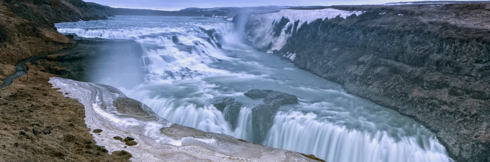
Gullfoss: The Waterfall That Almost Did Not Survive
Gullfoss is Iceland’s most famous waterfall, and it deserves to be. The river Hvita drops in two stages — eleven and twenty-one metres — into a seventy-metre-deep crevice that seems to swallow the water whole. In summer, the flow rate reaches a hundred and forty cubic metres per second: a mass of milky glacial water plunging with a force you feel in your chest. The spray creates permanent rainbows when the sun is out. In winter, the edges freeze and the falls become an ice sculpture.
But the story of Gullfoss is as important as its beauty. In the early twentieth century, British investors negotiated with the Icelandic government to build a hydroelectric dam that would have destroyed the waterfall. The land belonged to Tomas Tomasson, a valley farmer, who opposed the plan. His daughter, Sigridur Tomasdottir, took the fight further: she walked to Reykjavik — a hundred and twenty kilometres over mountain tracks — to hire a lawyer. She threatened to throw herself into the falls if the dam was built. The court case was lost, but the lease expired without the dam being constructed. Decades later, the government purchased the land and protected it.
Sigridur did not win in court, but her fight changed the conversation. She is considered Iceland’s first environmentalist, and her story is taught in schools. On the upper terrace at Gullfoss there is a plaque in her memory. It is a reminder that the landscapes we see do not exist by accident: they exist because someone decided to defend them.
Recommended time: 45 minutes. There are two viewing platforms: the upper one offers the panoramic view, the lower one brings you close to the edge of the falls. Both are worth the walk. Wind and spray will soak you: bring a waterproof jacket.
Beyond the Triangle: The Expanded Golden Circle
Kerid: The Postcard Crater
Fifteen minutes south of Geysir, on the return road toward Selfoss, the Kerid volcanic crater is a fifteen-minute stop that earns every second. It is a three-thousand-year-old explosion crater with walls of red and black rock and a blue-green lake at the bottom. You can walk around the rim (ten minutes) or descend to the lake (five minutes more). Entry costs 400 ISK, which is practically free by Icelandic standards.
What makes Kerid interesting is that the crater was not formed by an upward explosion but by a collapse: the magma drained and the chamber caved in. The result is a natural amphitheatre of almost perfect form. Bjork performed a concert from a barge on the lake in 1999. It is that kind of place.
Fludir and the Secret Lagoon
Fludir is a farming village twenty minutes east of Gullfoss that is home to the Secret Lagoon (Gamla Laugin), Iceland’s oldest natural thermal pool. It has been operating since 1891. It is an open-air pool of hot water — 38 to 40 degrees year-round — surrounded by grass, steam, and a small geothermal spring bubbling beside the edge.
The Secret Lagoon is everything Blue Lagoon is not: no crowds, no designer architecture, no extravagant price (3,000 ISK compared to Blue Lagoon’s 12,000-20,000), and with an authenticity that cannot be manufactured. It is hot water from the earth in a village of three hundred people. If you want to understand what geothermal energy means to Icelanders in their daily lives — not as a tourist attraction but as a domestic reality — this is the stop.
Fridheimar: Tomatoes Below the Arctic
Fridheimar is a greenhouse-restaurant ten minutes from Geysir that deserves attention not for the food — which is good: tomato soup and fresh bread — but for what it represents. It is a tomato greenhouse heated by geothermal energy, lit with artificial lights in winter to compensate for the lack of sun, producing tomatoes year-round at 64 degrees north latitude.
Iceland grows eighty per cent of its leafy greens and nearly all its tomatoes and cucumbers in geothermal greenhouses. In a country that imports almost everything else, self-sufficiency in fresh vegetables is an achievement that depends directly on the heat of the earth. Fridheimar makes this tangible: you eat surrounded by tomato plants in full production, with geothermal steam visible through the windows. It is agriculture as an act of climate resistance.
Book ahead in summer. Lunch is served between 12:00 and 16:00. The tomato soup with bread is the signature dish. Prices are moderate for Iceland.
Skalholt: The Forgotten Capital
Fifteen kilometres from Fludir, Skalholt was the religious and cultural capital of Iceland for seven hundred years: from the founding of the bishopric in 1056 to its transfer to Reykjavik in 1796. Here the first school in Iceland was built, the first books in Icelandic were printed, and the decision to adopt Christianity was taken in the year 1000 — a decision that, according to the sagas, was delegated to a pagan because he was the most just man available.
The current cathedral is modern — the original was destroyed by an earthquake in 1784 — but the site retains its historical weight. In the basement there is an excavated tunnel containing the sarcophagus of Bishop Pall Jonsson, discovered in 1954. It is a quiet place, free of tourists, where you can feel the historical depth of Iceland in a way that the waterfalls do not offer.
How to Do the Golden Circle Without the Crowds
The key is timing. Tour coaches leave Reykjavik between eight and nine in the morning and follow a predictable circuit: Thingvellir first, Geysir at midday, Gullfoss in the afternoon. If you drive the circuit in the opposite direction — Gullfoss early, Geysir mid-morning, Thingvellir in the afternoon — you will cross paths with the coaches rather than follow them.
Better still: spend a day and a half. Sleep in Selfoss, Fludir, or Laugarvatn the night before. Leave early for Gullfoss — at eight in the morning you may have it to yourself. Continue to Geysir. Lunch at Fridheimar or Fludir. Visit Skalholt and Kerid in the afternoon. Save Thingvellir for the following morning, before the day’s coaches have arrived.
From Reykjavik: 45 minutes to Thingvellir, 1.5 hours to Geysir, 2 hours to Gullfoss. The full circuit is approximately 230 km.
Car vs. tour. If you have a car, do not take a tour. The freedom to set your own schedule is the difference between seeing the Golden Circle and understanding it. Tours are efficient but designed to maximise stops per hour, not comprehension per stop.
Petrol. Stations in Selfoss, Laugarvatn, and near Geysir. Not an issue on this circuit.
Food. Fridheimar for lunch. Failing that, the restaurant at Hotel Geysir serves acceptable food. At Thingvellir there is a basic cafe in the visitor centre. Bring snacks: some stretches between stops have no services.
Why the Golden Circle Matters
The Golden Circle is popular for a reason that goes beyond tourism marketing: in a hundred kilometres it concentrates the three forces that define Iceland. The tectonic plates at Thingvellir explain why the island exists. The geothermal energy at Geysir explains how it functions. And the waterfall at Gullfoss, with Sigridur’s story, explains how Icelanders have chosen to relate to their land: using it, but protecting it.
None of that is grasped from the window of a coach. It is grasped by walking through the Almannagja rift with enough time to look at the rock walls and understand that they are moving. It is grasped by waiting for the third or fourth eruption of Strokkur until you stop taking photographs and simply watch. It is grasped by reading Sigridur’s plaque at Gullfoss and thinking about what would have happened if nobody had walked a hundred and twenty kilometres to say no.
The Golden Circle is not an excursion. It is an introduction to Iceland. And like any good introduction, it deserves more time than most people give it.
More on Iceland
Keep reading.
Other pieces from the same destination.

Next step
Ready for Iceland?
The guide is for travelling.
Offline maps, itineraries and everything that doesn't fit in an article.
Get the Iceland guide