
Iceland · 12 May 2026
Iceland's South Coast: Glaciers, Black Beaches, and Waterfalls
The south coast holds Iceland's most dramatic landscapes. From Seljalandsfoss to Jökulsárlón, a route that explains why this island is unlike anything else.

The south coast of Iceland is a place where geology has not finished its work. Glaciers are still carving valleys, volcanoes still burying pastures under ash, black sand beaches still growing with every glacial flood, and waterfalls still falling from cliffs that the ice cut ten thousand years ago. Nowhere else in Europe does the landscape feel so active, so present, so willing to remind you that the earth is not a stable surface but a system in constant motion.
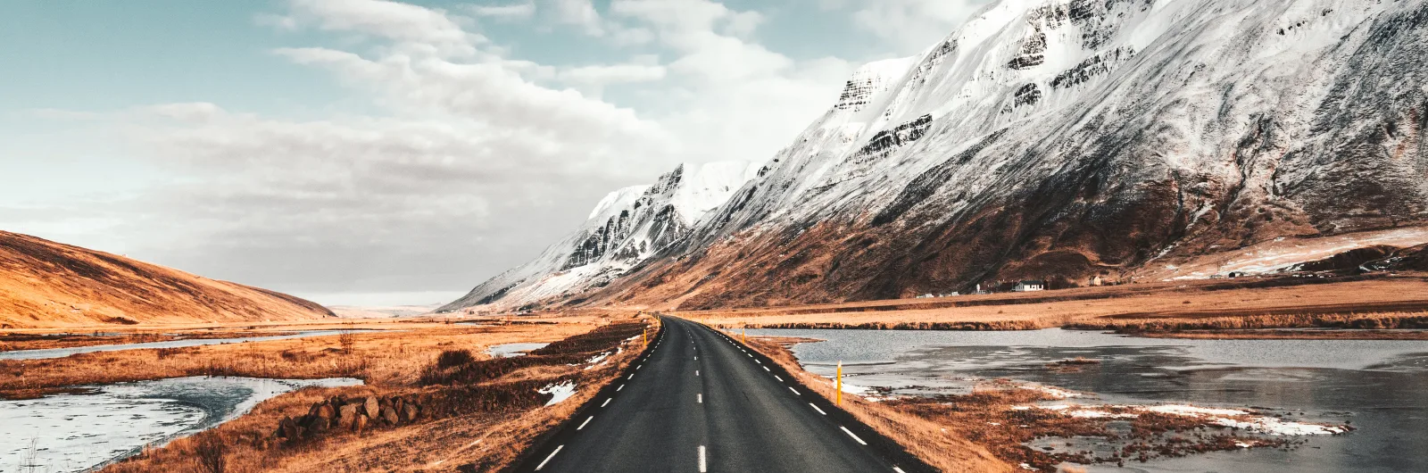
The route along the south coast follows the Ring Road (Route 1) from Selfoss to Jokulsarlon: three hundred kilometres of paved road crossing volcanic sand plains, passing beneath waterfalls, skirting glacier tongues, and ending at a lagoon where icebergs drift toward the ocean. It is the most spectacular section of the Ring Road and therefore the most visited. But the density of what there is to see is such that even in peak season, the moment you step away from the main car parks, you find solitude.
This guide follows the south coast from west to east, in the order you will encounter it coming from Reykjavik. The full route requires a minimum of two days — three if you want to hike in Skaftafell and spend proper time at Jokulsarlon. Driving it in a single day, as some tours do, is technically possible but absurd: it is the equivalent of running through a museum.
Seljalandsfoss: The Waterfall You Can Walk Behind
The first great waterfall of the south coast appears to the right of the road, visible from kilometres away: a jet of water plunging sixty metres from a grass-covered cliff. Seljalandsfoss is famous because you can walk behind the curtain of water, along a path that circles the falls through a natural cave in the rock. The experience is exactly what it promises: water falling in front of you, the green valley behind seen through the curtain, and the certainty that you are going to get completely soaked.
The trail can be slippery and closes in winter due to ice. In summer, the evening light coming through the water from the west creates something that justifies arriving late rather than early.
But the real stop is five hundred metres to the south, at the end of a short trail passing between two rock walls that grow steadily narrower. Gljufrabui — the hidden waterfall — falls inside a semi-enclosed cave. You need to cross a stream on stepping stones to reach the opening, and inside the water drops from a crack in the ceiling into a pool surrounded by vertical walls carpeted in moss. It is smaller than Seljalandsfoss, but the feeling of discovery — that the waterfall has hidden itself deliberately — makes it memorable. Most tour coaches skip it because the path is not obviously signposted.
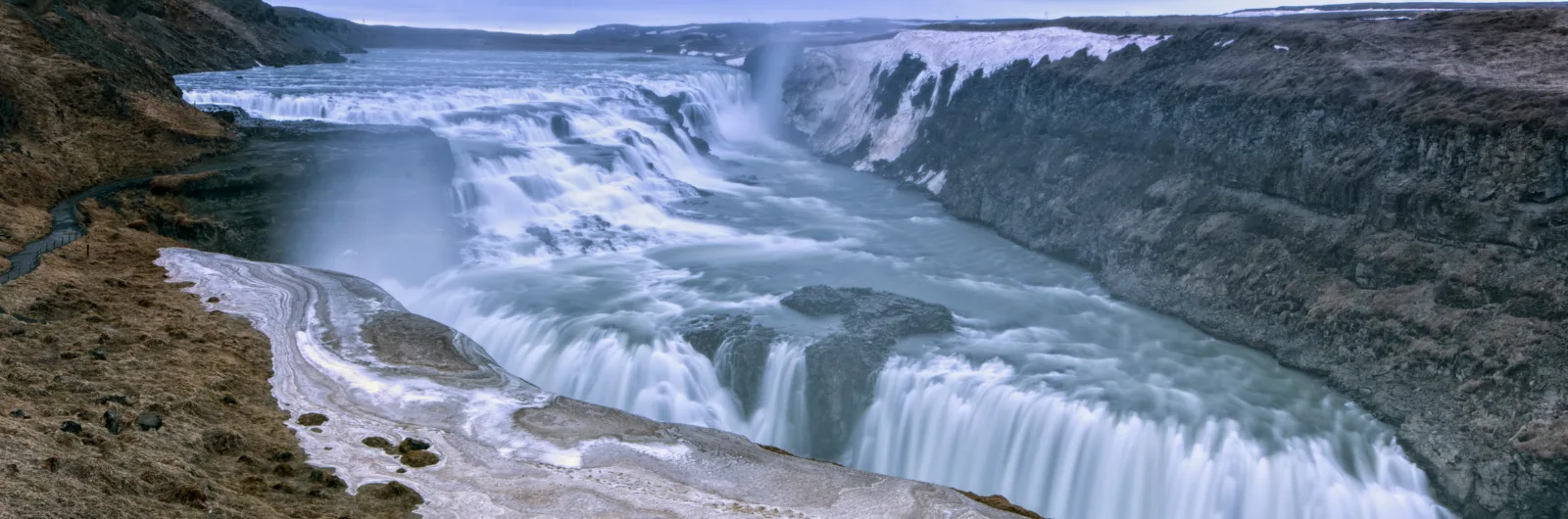
Skogafoss and the Trail That Climbs to the Sky
Ten kilometres further east, Skogafoss is brute force where Seljalandsfoss is elegance. Twenty-five metres wide, sixty metres of drop, a volume of water that strikes the base with a violence you feel as vibration through the ground. The spray generates a permanent rainbow — sometimes a double — when the sun is out. According to legend, the Viking settler Thrasi Thorolfsson hid a chest of gold behind the waterfall. Centuries later, a group of locals found a ring from the chest, but the chest itself was never recovered. The ring is kept in the local museum at Skogar.
The Skogar Museum, beside the waterfall, is worth half an hour. It is a small regional collection but with everyday objects — fishing tools, farm implements, clothing, books — that tell the story of rural Icelandic life over the last centuries better than any written account. The reconstructed turf houses behind the museum show how most Icelanders lived well into the twentieth century: practically underground, in structures of stone and grass designed to survive the wind and the cold.
To the right of Skogafoss, a metal staircase climbs to the upper edge of the falls. From the top, the Skoga river winds inland between green mountains, and a marked trail follows its course toward the Fimmvorduhals pass, between the Eyjafjallajokull and Myrdalsjokull glaciers. It is one of Iceland’s best day hikes (25 km, 8-10 hours), crossing a landscape of twenty successive waterfalls, snowfields, and the fresh lava from the 2010 Eyjafjallajokull eruption. The full hike requires a complete day and solid fitness, but walking the first two kilometres from the waterfall already offers views that repay the effort.
Kvernufoss: The Waterfall Nobody Visits
Ten minutes on foot behind the Skogar Museum, following a path that crosses a farm fence, is Kvernufoss: a thirty-metre waterfall that, like Seljalandsfoss, you can walk behind. The difference is that here there is nobody. No marked car park, no signs, no tourists. It is the same experience as Seljalandsfoss — walking behind a waterfall — but in solitude. The reason so few people visit is simply that it does not appear in the standard Golden Circle extended itinerary. It is one of those Icelandic oddities where overcrowding and solitude are separated by five hundred metres and a sign that does not exist.
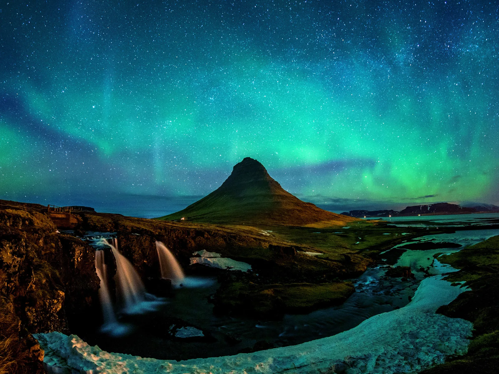
Solheimajokull: Touching a Glacier
Between Skogafoss and Vik, a four-kilometre detour leads to Solheimajokull, a glacier tongue of the Myrdalsjokull that descends almost to the road. It is the most accessible glacier on the south coast: from the car park, a fifteen-minute trail leads to the edge of the lagoon where the ice meets the meltwater.
What you see is unsettling. The glacier is covered in black volcanic ash — residue from eruptions of Katla and Eyjafjallajokull — giving it a dirty, industrial appearance, nothing like the mental image of white and blue ice. Markers beside the trail indicate where the glacier’s edge was in previous years. In 2000, the ice reached where the car park now begins. In twenty years it has retreated hundreds of metres. This is not an abstract statistic: it is a landscape that has changed within the memory of any living adult.
You can book a guided glacier walk with crampons (approximately two hours, 10,000-15,000 ISK). It is the most direct way to understand what a glacier is: not a flat surface of ice but a frozen river full of crevasses, ridges, blue meltwater pools, and formations that change every week.
Reynisfjara: The Beach That Bites
The black sand beach at Reynisfjara, beside the village of Vik, is the iconic landscape of the south coast: coal-black sand that crunches underfoot, hexagonal basalt columns forming a natural cave in the cliff face, and the Reynisdrangar rock stacks rising from the sea like the fingers of a petrified giant. According to legend, they are trolls who tried to drag a ship ashore and were turned to stone by the dawn light. The geology is less poetic but equally fascinating: they are remnants of an ancient cliff eroded by the sea.
Reynisfjara is also the most dangerous place on the south coast, and that needs to be said plainly. The Atlantic waves that reach here are called sneaker waves: waves that look normal from a distance but reach far higher up the beach than expected, with enough force to drag a person into the water. The undertow does the rest. There are deaths every year. The warning signs are explicit and posted in multiple languages. The rule is simple: never turn your back on the sea, never go within thirty metres of the waterline, and assume the next wave will be bigger than the last.
With that precaution clearly understood, Reynisfjara is an extraordinary place. The basalt columns of the Halsanefshellir cave have a perfect hexagonal geometry — the result of slow lava cooling, which contracts into regular prisms like dried mud but on a scale of metres. It is the same phenomenon as the Giant’s Causeway in Northern Ireland, but here the context is wilder: open ocean, constant wind, and a black beach stretching kilometres in both directions.
Vik: Living Beneath a Volcano
Vik i Myrdal is the southernmost village in Iceland, with three hundred inhabitants, a white church on the hill, and the invisible presence of Katla a few kilometres to the north. Katla is one of Iceland’s most active volcanoes: it has erupted every forty to eighty years over the past millennium. The last major eruption was in 1918. Statistically, we are within the recurrence period.
What would make a Katla eruption dangerous is not the lava but the jokulhlaup: the glacial flood. The volcano sits beneath the Myrdalsjokull glacier, and an eruption would melt vast quantities of ice in minutes, generating a torrent of water, ice, and sediment that would devastate the coastal plain. The road between Vik and Skogafoss crosses the sandur — the black sand plain formed by previous floods — and the evacuation signs are visible on both sides of the road. The inhabitants of Vik practise evacuation drills regularly. The church on the hill is the assembly point.
None of this makes Vik an unsettling place. On the contrary: it is a quiet village with excellent Icelandic wool at its cooperative shop, a soup restaurant (Supa) that is perfect for lunch, and a view of the Reynisdrangar stacks from the church hill that is one of Iceland’s finest postcards.
The Sandur: The Plain the Floods Left Behind
Between Vik and Skaftafell, the road crosses a hundred and thirty kilometres of sandur: plains of black volcanic sand where nothing grows. These are Iceland’s largest alluvial plains, formed by centuries of jokulhlaups — glacial floods triggered by volcanic eruptions beneath the glacier. The appearance is lunar: flat black extending to the horizon, with the glacier to the north and the sea to the south.
The Laki eruption of 1783 was one of the greatest volcanic disasters of the modern era. Over eight months, a twenty-five-kilometre fissure expelled lava and toxic gases that killed twenty per cent of Iceland’s population — mainly through famine, as livestock died from fluorine gases — and altered the climate of the northern hemisphere for years. The cloud of sulphur dioxide reached mainland Europe and contributed to the crop failures that, according to some historians, fuelled the discontent that led to the French Revolution. The sandur you cross by car is, in part, the legacy of that eruption.
Skaftafell and Svartifoss: The Basalt Waterfall
Skaftafell is the gateway to Vatnajokull National Park on the south coast. It is a green oasis at the foot of the glacier, with birch forests — a rarity in Iceland — and a network of trails ranging from one-hour walks to multi-day expeditions.
The most popular trail leads to Svartifoss, the black waterfall: a twenty-metre cascade framed by columns of black basalt hanging from the cliff edge like the pipes of an organ. The columns formed through the slow cooling of a lava flow, the same process as at Reynisfjara but here oriented vertically. The result is a waterfall that looks as though it was designed by a brutalist architect. In fact, it was used as one: Gudjon Samuelsson, the architect of Hallgrimskirkja and the National Theatre of Reykjavik, drew direct inspiration from Svartifoss for both buildings.
The trail to Svartifoss is 5.5 kilometres return (ninety minutes to two hours), with moderate elevation gain. From the Sjonarnipa viewpoint on the upper section of the trail, the view of the Skeidararjokull glacier and the coastal plain is one of the broadest in Iceland: ice, black sand, and sea in a single panorama.
Jokulsarlon: The Glacier Coming Undone
Jokulsarlon is a glacial lagoon where icebergs calved from the Breidamerkurjokull glacier float slowly toward the Atlantic. It is a spectacle of a beauty that is difficult to absorb: blue, white, and black icebergs — the black ones stained by volcanic ash trapped in the ice — drifting in still water, rotating slowly, melting, splitting apart. Seals swim among the blocks of ice. The light changes the colour of the water every hour.
But Jokulsarlon is not an eternal landscape. The lagoon did not exist a hundred years ago. In 1935, the glacier reached the sea. Since then, the retreat has been constant: the lagoon now covers more than eighteen square kilometres and continues to grow. Every iceberg you see is ice formed hundreds or thousands of years ago that has broken from the glacier and will not return. The beauty of Jokulsarlon is, quite literally, the beauty of a loss.
There are amphibious boat tours of the lagoon (5,500 ISK, 40 minutes) and zodiac tours (10,000 ISK, 1 hour). The zodiac gets closer to the icebergs and is worth the price difference. But the view from the shore — especially from the bridge where the road crosses the channel connecting the lagoon to the sea — is already extraordinary.
Diamond Beach: Where the Ice Dies
On the other side of the road, where the Jokulsarlon channel meets the Atlantic, the smaller icebergs become stranded on the black sand. The name Diamond Beach — unofficial but now universal — describes perfectly what you see: fragments of transparent and blue ice on black volcanic sand, polished by water and sand until they resemble cut gems. The contrast is absurd. It looks artificial. It is not.
The beach changes every hour: the tide and the swell deposit new fragments and carry others away. The early hours of the morning, when the light is low and the tourists few, are the best time. The wave warnings apply here too: keep your distance from the water.
Practical Notes for the South Coast
Distances and times. Selfoss to Seljalandsfoss: 60 km, 45 minutes. Seljalandsfoss to Vik: 75 km, 1 hour. Vik to Skaftafell: 130 km, 1.5 hours. Skaftafell to Jokulsarlon: 60 km, 45 minutes. Total Selfoss to Jokulsarlon: 325 km, 4.5 hours of driving. With stops, you need a minimum of two days.
Petrol. Stations at Selfoss, Hella, Hvolsvollur, Vik, and Kirkjubaejarklaustur. Between Vik and Kirkjubaejarklaustur there are 75 km with no services. Do not let the tank run low.
Food. Supermarket in Selfoss (Kronan) and Vik (small). Restaurants in Vik: Supa (soup), Smidjan (pizza), Black Beach Restaurant. At Skaftafell there is a basic cafe. At Jokulsarlon, a cafe beside the car park. Bring prepared food: the long stretches between villages have nothing.
Accommodation. Book months in advance for summer, especially in Vik and near Jokulsarlon. Options are guesthouses, farms, and the occasional hotel. The Skaftafell campsite is a good base for exploring the eastern section. Hofn, an hour east of Jokulsarlon, has more accommodation options.
Weather. Wind on the sandur can be brutal: gusts of sand that reduce visibility and damage car paintwork. The sand insurance on your rental is not a luxury. Horizontal rain is common along the entire south coast. Full waterproof clothing: jacket, trousers, and protection for your camera.
Safety. Reynisfjara: respect the distance from the water. Glaciers: do not walk on ice without a guide and crampons. Trails: conditions change quickly; carry a downloaded map and warm clothing even if it is sunny when you set out. The Katla evacuation signs are not decorative: if the alarm sounds, move to high ground immediately.
More on Iceland
Keep reading.
Other pieces from the same destination.
Next step
Ready for Iceland?
The guide is for travelling.
Offline maps, itineraries and everything that doesn't fit in an article.
Get the Iceland guide