

Uzbekistan · 10 April 2026
The Silk Road in Uzbekistan: history and itinerary
The legacy of the Silk Road lives on in Uzbekistan. A journey through the cities that connected East and West for centuries.
The Silk Road was not a road. Nor was it, strictly speaking, about silk. It is one of those expressions that succeeded precisely because they simplify something that was, in reality, infinitely more complex: a network of paths, trails, mountain passes, river ports and oases that, for more than fifteen centuries, connected the farthest reaches of the known world. Along that network travelled silks, yes, but also spices, paper, gunpowder, religions, epidemics, mathematical ideas, irrigation techniques and ways of understanding the universe.
And at the geographical centre of that entire network, with a precision that seems deliberate, sits Uzbekistan.
The name a German invented
It is worth starting at the beginning, which in this case is slightly misleading. The term “Silk Road” — Seidenstraße in German — was not coined by any medieval merchant or ancient explorer. It was invented in 1877 by the German geographer Ferdinand von Richthofen, uncle of the famous Red Baron, on a map that attempted to trace the trade routes between China and the Mediterranean.
Before Richthofen, nobody called these routes that. The Sogdian merchants who travelled them in the fifth century had no poetic name for what they did: they simply traded. The Chinese spoke of the “western territories.” The Romans knew that silk came from some remote place they called Serica, but they were not entirely clear on the route it took.
What did exist, from at least the second century BC, was a constant flow of goods and people between Chang’an (modern Xi’an, then capital of Han China) and the ports of the eastern Mediterranean. That flow had nodes — obligatory stops where merchants rested, changed caravans, negotiated prices and, often, stayed. The most important nodes of the entire network were in the region we now call Uzbekistan.
Why Uzbekistan: geography as destiny
Uzbekistan’s position on the Silk Road was not accidental. It was geographically inevitable.
To the north, the steppes of Kazakhstan were passable but dangerous, dominated by nomads who could facilitate or destroy a caravan as it suited them. To the south, the Hindu Kush mountains and the Karakum desert imposed formidable barriers. To the east, the Pamir and Tien Shan passes were the only points where one could cross into China. To the west, the Iranian plateau led towards Mesopotamia and, eventually, the Mediterranean.
At the centre of all this, watered by the Amu Darya and Syr Darya rivers — the ancient Oxus and Jaxartes of the Greeks — lay a corridor of fertile oases where it was possible to farm, raise livestock, store water and, above all, rest. Samarkand, Bukhara and the oases of Khorezm (the Khiva region) did not exist by chance: they existed because the water allowed it and the geography demanded it.
Every caravan that wanted to travel from China to the Mediterranean overland had to pass through here. There was no reasonable alternative. And that turned this region into something more than a stop: it turned it into the largest marketplace of the ancient world.
The Sogdians: history’s invisible traders
If there is one people who embody the Silk Road, it is not the Chinese, nor the Romans, nor the Arabs. It is the Sogdians, an Iranian people who inhabited the Zerafshan valley — exactly where Samarkand and Bukhara stand today — and who dominated transcontinental trade from the fourth to the eighth century.
The Sogdians were bilingual, multicultural, pragmatic. They spoke their own Iranian language but learned Chinese, Turkic, Sanskrit — whatever was needed. Their alphabet, derived from Aramaic, became the lingua franca script of Central Asian commerce. They founded trading colonies from China to Byzantium. In the Chinese capital of Chang’an there was an entire Sogdian quarter, with its Zoroastrian temples and taverns.
The Afrosiab Museum, on the outskirts of Samarkand, preserves the frescoes of a seventh-century Sogdian residence that are probably the finest visual testimony of this vanished world. They depict diplomats, merchants, processions, exotic animals: a cosmopolitan and sophisticated world that preceded the modern concept of globalisation by many centuries.
When the traveller sets foot in Samarkand, they walk on Sogdian ground. The buildings they see are later — Timurid, mostly — but the reason the city exists in that precise spot, in that valley, beside that river, is Sogdian.
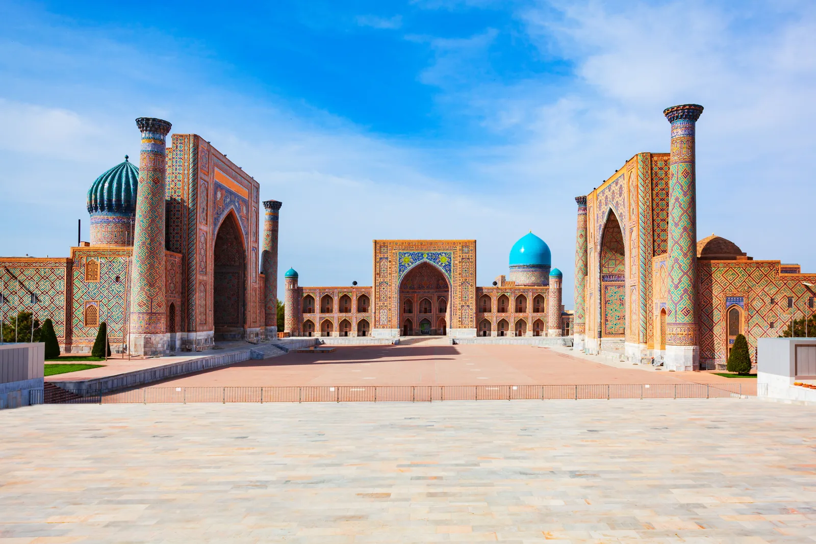
Samarkand: the crossroads of the world
Samarkand was already ancient when Alexander the Great conquered it in 329 BC and described it as “more beautiful than I had imagined.” The Greeks called it Maracanda. The Arabs, upon conquering it in the eighth century, were equally impressed and turned it into a centre of paper production — a technology they had learned, precisely, from Chinese prisoners captured at the Battle of Talas in 751.
That detail matters. The Battle of Talas, fought a few hundred kilometres east of Samarkand, is one of those hinge events that changed the course of civilisation. The Abbasid Arabs defeated the Tang Chinese, and among the spoils they obtained Chinese papermakers who taught the victors how to manufacture paper. Samarkand became the main paper production centre of the Islamic world. From there, the technology spread to Baghdad, to Cairo, to Al-Andalus and, finally, to all of Europe. Before Gutenberg, there was Samarkand.
But the moment of greatest splendour would come with Tamerlane — Amir Timur — in the fourteenth century. Timur, a ruthless conqueror and an equally fierce patron of the arts, chose Samarkand as the capital of his empire and set out to make it the most beautiful city in the world. The artisans he brought — Persian, Syrian, Indian, often deported by force — built the Registan, Bibi-Khanym, the mausoleums of Shah-i-Zinda and the Gur-e-Amir where Timur himself rests.
What the traveller sees today in Samarkand is, to a large extent, Timur’s city. But beneath its foundations lie Sogdian, Greek, Arab and Mongol layers. Each conquest destroyed and rebuilt, but none could move the city from where it stood, because the water and the geography continued to dictate the rules.
Bukhara: where knowledge weighed more than gold
If Samarkand was the muscle of the Silk Road — the scale, the grandeur, the power — Bukhara was the brain. For centuries, Bukhara was one of the most important intellectual centres of the Islamic world, comparable to Baghdad, Cordoba or Cairo.
Here, in 980, Ibn Sina (Avicenna) was born, whose Canon of Medicine was a standard text in European universities until the seventeenth century. Here al-Bukhari taught, compiler of the most important collection of hadith in Sunni Islam. Here, in the dozens of madrasas scattered across the old town, theology, astronomy, mathematics, medicine and law were studied while much of Europe still lived in the intellectual darkness of the early Middle Ages.
The difference between Samarkand and Bukhara is felt in the walking. Samarkand has colossal monuments, squares designed to impress, a scale that seeks to overwhelm. Bukhara has narrow lanes, bazaars roofed with medieval domes still in use, neighbourhood mosques, madrasas that are modest on the outside and exquisite within. It is a city that grew great not through force but through the patient accumulation of learning and trade.
The Kalon Minaret, built in 1127 and visible from kilometres away, survived even Genghis Khan, who razed Bukhara in 1220 but, according to legend, looked up at the minaret and ordered it spared. Whether true or not, the fact that it still stands nine hundred years later, while everything around it was destroyed and rebuilt several times, says something about Bukhara’s relationship with permanence.
Trade along the Silk Road in Bukhara was not only in physical goods. It was a trade in ideas. The manuscripts copied in its madrasas travelled west and east with the same fluidity as silks and spices. And ideas, unlike silk, did not wear out with use: they multiplied.
Khiva: the last frontier
If Samarkand and Bukhara were the heart of the Silk Road, Khiva was its western outpost in Central Asia. Situated in the Khorezm oasis, near the mouth of the Amu Darya, Khiva controlled the passage towards Persia and, beyond, towards the Caspian and the Caucasus.
Khorezm was, for centuries, an independent power. Its school of mathematics was extraordinary: al-Khwarizmi, the man whose name gave rise to the word “algorithm” and whose treatise popularised the Indian numeral system in the Islamic world, was from this region. The term “algebra” comes from the title of his book Al-Jabr, written in Baghdad but with intellectual roots in Khorezm.
The Khiva we see today, however, is more recent. Ichan-Kala, the walled inner city, dates mainly from the eighteenth and nineteenth centuries, when Khiva was the capital of an independent and prosperous khanate that thrived on trade, agriculture and, it must be said, slavery. The slave markets of Khiva were famous and feared throughout Central Asia. It was precisely the abolition of slavery that served as one of the pretexts the Russian Empire used to conquer the khanate in 1873.
What makes Ichan-Kala unique is not a single monument but the ensemble: an entire city of mud brick, fired brick and tile that has survived as a complete organism. It is the closest thing there is to stepping into a Silk Road city as it once was, with its proportions, its human scale and its streets designed for the passage of camels, not cars.
The Registan of death: the desert crossing
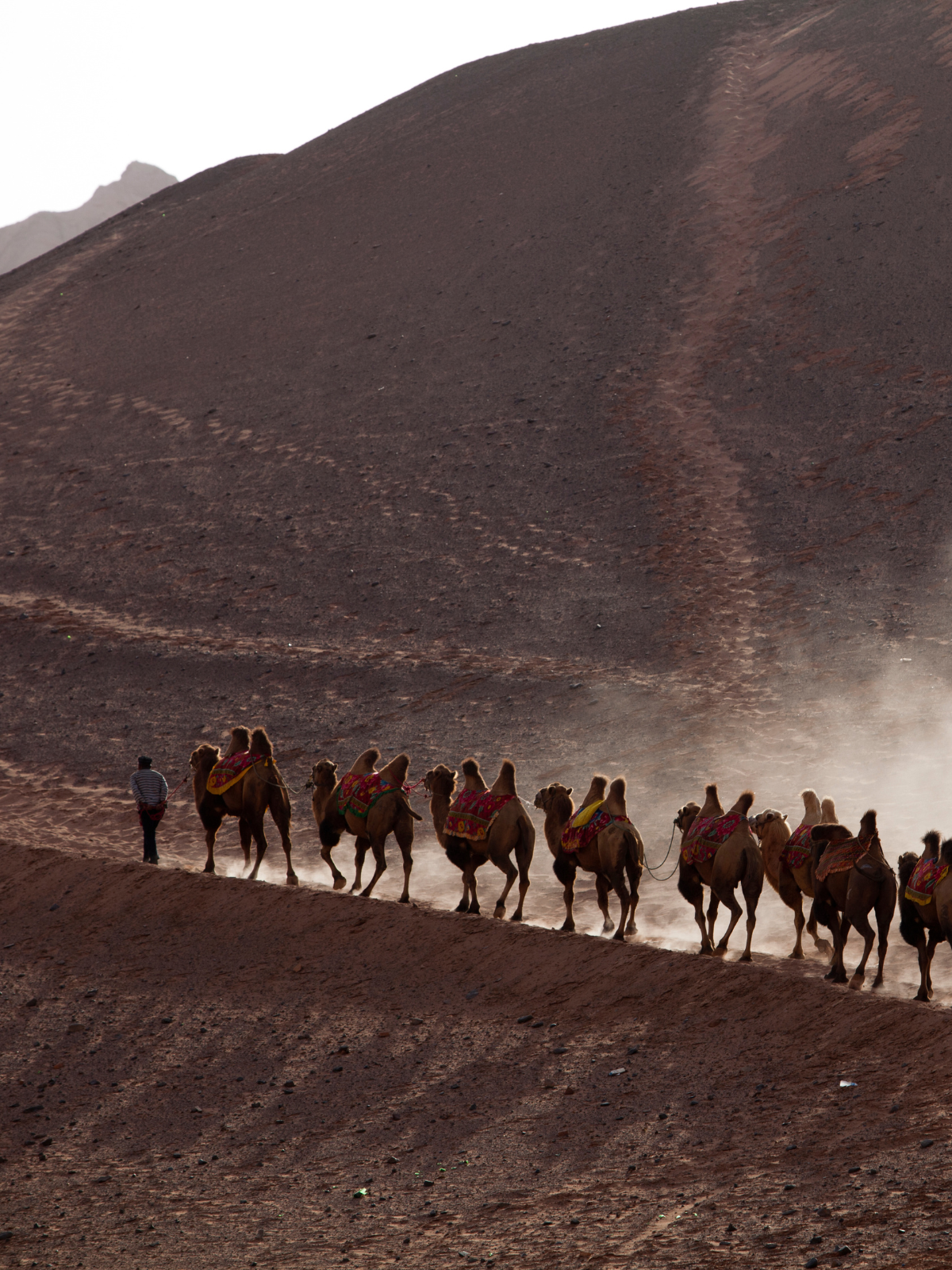
There is an aspect of the Silk Road that romantic books tend to omit: death. Travelling these routes was dangerous. The stretch between Bukhara and Khiva, which today can be covered by shared taxi in six hours with air conditioning, was known as one of the most deadly of the entire network.
The Kyzylkum desert — “red sands” in Turkic — stretches between both cities like a sea without water. Caravans that crossed it needed expert guides, enough water for days of marching and, above all, luck. Bandits were a constant threat, but the desert itself was the worst enemy: sandstorms, extreme heat, dry wells.
Today, when the traveller looks out of the taxi window and sees the endless steppe, the occasional dunes, the camels grazing in the void, they are seeing exactly what Sogdian merchants saw fifteen hundred years ago. The landscape has not changed. Only the speed at which it is crossed.
What remains: stone, tile and memory
The Silk Road as a commercial system died slowly between the fifteenth and seventeenth centuries, strangled by the maritime routes that the Portuguese and Spanish opened by rounding Africa and crossing the Atlantic. When Vasco da Gama reached India in 1498, it began to be cheaper — and safer — to transport goods by sea than overland. The cities of Central Asia, which had lived off transit, lost their economic reason for being.
What followed were centuries of relative decline: isolated khanates, internal wars, and finally absorption by the Russian Empire and the Soviet Union. Samarkand, Bukhara and Khiva went from being centres of the world to provincial cities in an empire that looked towards Moscow.
But the stone and the tile endured. And with them, the memory. When Uzbekistan gained independence in 1991, reclaiming the Silk Road as an identity narrative was an almost obvious decision: what better story for a new country than to remember that, for centuries, it was the centre of the world?
The traveller who today follows the Tashkent-Samarkand-Bukhara-Khiva route is doing, in a compressed and comfortable version, what merchants, pilgrims, diplomats and adventurers did for millennia. The scale has changed: where it once took weeks, it now takes hours. But the places are the same. The tiles that gleam in the morning sun at the Registan in Samarkand are the same ones that the ambassadors of Ruy Gonzalez de Clavijo saw when they arrived at Tamerlane’s court in 1404 and could not believe what lay before them.
The Silk Road is not just history. It is the reason Uzbekistan exists as it does, where it does, and how it understands itself. Grasping that before you travel changes the experience completely. Every madrasa, every minaret, every domed bazaar stops being an isolated monument and becomes a piece of a system that connected civilisations for longer than most present-day countries have existed.
For the full picture of every city, route and hidden corner in Uzbekistan, the Far Guides complete guide has it all: interactive maps, up-to-date information and offline access.
More on Uzbekistan
Keep reading.
Other pieces from the same destination.


Next step
Ready for Uzbekistan?
The guide is for travelling.
Offline maps, itineraries and everything that doesn't fit in an article.
Get the Uzbekistan guide