
Iceland · 5 July 2026
Jökulsárlón: the glacial lagoon where time stopped
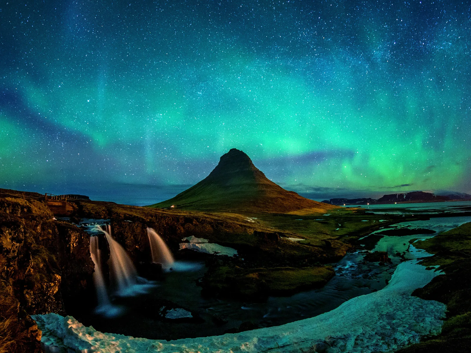
Jökulsárlón is Iceland's deepest lake and one of the planet's most photogenic landscapes: blue and white icebergs drifting to sea beneath Europe's largest glacier.

In 1935, when Iceland’s first modern cartographers attempted to map the south-eastern coastline with precision, Jökulsárlón did not exist. The Breiðamerkurjökull glacier reached all the way to the road — or rather, to where the road would have been, had there been one. What is today an 18-square-kilometre lagoon was then solid ice. The water now drifting in blue icebergs towards the Atlantic was, ninety years ago, part of a glacier that ran unbroken from the summits of Vatnajökull down to the ocean’s edge.
What melting has built
Jökulsárlón — literally “glacial river lagoon” in Icelandic — is the direct product of the Breiðamerkurjökull’s retreat. This is one of the outlet glaciers of Vatnajökull, Europe’s largest ice cap, which covers roughly eight percent of Iceland’s total surface. The lagoon began forming in the second half of the twentieth century and has grown at a rate that glaciologists routinely use as a reference when they need visible indicators of climate change. Since the 1970s, it has quadrupled in size. Its current depth exceeds 250 metres, making it Iceland’s deepest lake.
The icebergs floating across the lagoon are fragments of the glacier shed through a process called calving: the weight of advancing ice causes entire blocks to break away from the face and fall into the water with a sound that guides describe as muffled thunder. These blocks can be the size of multi-storey buildings. They float for years in the lagoon, slowly hollowing out, while wind and water give them forms no sculptor could have planned.
The colour of old ice
The blue of certain icebergs is not a trick of the light — it is an optical property of highly compressed ice. When ice forms under the weight of successive snow layers over decades or centuries, air bubbles are expelled and the molecular structure of solid water absorbs most of the visible spectrum except blue, which it reflects. The oldest ice in Vatnajökull is around a thousand years old. This means that water currently floating in the lagoon fell as snow in the eleventh century, before most European capital cities existed in anything like their present form. White icebergs, by contrast, contain trapped air: younger ice, more porous, less compressed.
The channel and the seals
Between the lagoon and the Atlantic runs a channel about two hundred metres wide, through which water moves in both directions depending on the tide. Icebergs follow this flow towards the ocean; those that survive the passage end up on Diamond Beach — the black basalt strand on the other side of Route 1 — where they strand and slowly reduce under sun and wind until they disappear. The combination of volcanic black rock and translucent ice blocks has something almost too deliberate about it, too theatrical to feel accidental, which makes the first view of it genuinely difficult to process.
Grey seals have made the channel and the lagoon their permanent territory. There is no particular season: they are present year-round, sleeping on the flattest icebergs, diving beneath the dark water, or watching visitors with the expression of benevolent indifference that characterises pinnipeds. On days with reasonable light they can be photographed from the shore without any specialist equipment.
Zodiac tours and what they give you
Several local operators run inflatable boat tours across the lagoon: around forty minutes, approximately €50 per person. The experience is worth the price not for the photographs it produces, though it does produce photographs, but for the sense of scale it gives to icebergs seen from water level. A block of ice that looks reasonably large from the shore turns out, when the boat approaches, to be three storeys high. The guide scoops pieces of floating ice from the water and passes them around: hundred-year-old ice that melts in your hand in under two minutes.
Getting there and what to expect
Jökulsárlón sits on the Ring Road, 370 kilometres east of Reykjavík — about four hours of driving without stops, more if you follow the south coast properly, which means stopping for cascades and black sand beaches along the way. The route passes beneath Eyjafjallajökull, along the beach at Reynisfjara with its basalt columns, and across the Eldhraun lava field at kilometre 202: 565 square kilometres of solidified lava from the 1783 Laki eruption, the greatest natural catastrophe in Icelandic recorded history.
The lagoon has no better hour than another, though summer afternoon light, when the sun drops towards the west, gives the icebergs a tone that photographs will nearly but not quite replicate. In winter, with snow on the ground and a clear sky, the scene has an austerity that summer cannot match. Jökulsárlón does not depend on the season. It works in any conditions because what it offers is not a light effect but a geological reality in motion.
The complete Far Guides Iceland guide includes detailed routes across the whole island, interactive maps and all the practical information you need to plan your Ring Road and beyond.
More on Iceland
Keep reading.
Other pieces from the same destination.


Next step
Ready for Iceland?
The guide is for travelling.
Offline maps, itineraries and everything that doesn't fit in an article.
Get the Iceland guide