
Iceland · 24 July 2026
The Westfjords: The Iceland Few People Know
The Westfjords are Iceland's most remote and least visited region. A guide for those seeking Iceland without filters.
The Westfjords are the part of Iceland that Iceland forgets to mention in its tourism campaigns. Not because they are not spectacular — they are, in a way that makes the rest of the country seem domesticated — but because promoting them would mean acknowledging that the infrastructure is not ready for mass tourism, and that perhaps it should not be. The Westfjords are a vast, jagged peninsula in Iceland’s northwest, connected to the rest of the country by an isthmus barely seven kilometres wide. Geologically, this is Iceland’s oldest territory: while the rest of the island ranges from one to twenty million years old, the rocks of the Westfjords exceed sixteen million. They are basalt mountains eroded by glaciers that no longer exist, deep fjords carved by ice, and cliffs that drop into the Arctic Sea without mediation.
Only two or three per cent of Iceland’s visitors reach the Westfjords. That figure says a great deal about the region and about travellers: most people do not come because the roads are long, slow, and unpaved; because services do not appear every twenty kilometres; because reaching anywhere requires time that most do not have or are unwilling to invest. Those who do come discover an Iceland that predates tourism, a landscape that has not been optimised for the visit, and a solitude that in the twenty-first century holds a value difficult to quantify.
How to get there, and why so few do
The Westfjords are not on the Ring Road. This apparently trivial fact is the main reason for their tourist isolation. The vast majority of travellers in Iceland drive the Ring Road — Route 1, the highway that circles the island — and the Westfjords lie outside that circuit, connected to the country’s northwest by secondary roads that add several hundred kilometres to any itinerary.
From Reykjavik, reaching Isafjordur — the region’s capital — involves roughly five hours of driving on the Ring Road to the Bru junction, then another two or three hours on Route 61 as it winds between fjords. There is also a ferry (Baldur) that crosses the Breidafjordur from Stykkisholmur (on the Snaefellsnes peninsula) to Brjanslaekur on the Westfjords’ southern coast, significantly reducing the distance. The ferry operates in summer and is the most efficient way to integrate the Westfjords into an itinerary that includes Snaefellsnes. Icelandair and PLAY operate occasional flights to Isafjordur, though frequency is limited and the airport is famously challenging due to its approach between mountains.
The roads within the Westfjords deserve separate explanation. Route 61, the main artery, is partially paved, but long stretches remain gravel. The secondary roads — those leading to Latrabjarg, Raudasandur, Dynjandi, and the more remote fjords — are narrow gravel tracks, winding, with steep gradients and no crash barriers above cliffs that fall to the sea. They are not F-roads (you do not legally need a 4x4), but a car with low ground clearance suffers on many stretches, and the driving demands an attention that bears no resemblance to cruising along the south coast.
Distances are deceptive. What looks on the map like a hundred-kilometre drive can take two hours or more, thanks to the combination of gravel, tight bends, and the need to travel at forty or fifty kilometres per hour. Planning long stages is a common mistake: the Westfjords demand a different pace.
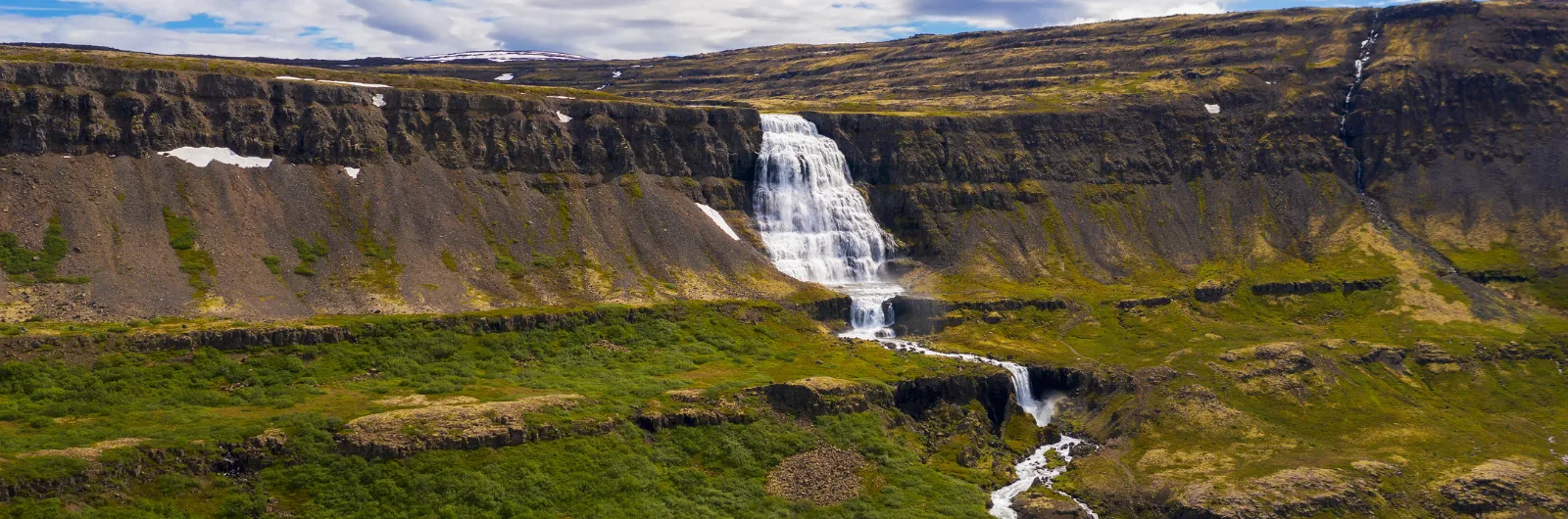
Dynjandi: the waterfall that justifies the journey
If the Westfjords had to present a single credential to the sceptical traveller, it would be Dynjandi. It is frequently described as the most beautiful waterfall in Iceland, and when you arrive you understand why without any need for hyperbole.
Dynjandi is not a vertical waterfall like Skogafoss or Seljalandsfoss. It is a bridal-veil cascade: the water falls from an edge roughly one hundred metres wide at the top and fans out over the basalt rock face, broadening progressively to about thirty metres at the base. The shape resembles a wedding dress, or an inverted basalt organ, and the sound is enveloping without being thunderous. The total height is around one hundred metres, but the visual effect is not one of height but of breadth: the water seems to cover the entire mountainside.
The path from the car park to the base of Dynjandi climbs alongside a series of smaller falls — Haifoss, Udafoss, Gongufoss, Hundafoss, Strompgljufrafoss, Baejarfoss, and Hristandi — that in any other context would be attractions in their own right. Here they are the prologue. The climb takes about fifteen minutes and is not technically difficult, but it is wet: the spray from the cascades keeps the path permanently damp.
Dynjandi sits on the Arnarfjordur, one of the widest and deepest fjords in the region. The waterfall is fed by snowmelt from the surrounding mountains, and its flow varies with the season: in June and July, when melt is at its peak, the curtain of water is denser and the spectacle more powerful. The car park charges a thousand kronur (about seven euros) and basic facilities are available. Camping beside the waterfall was permitted until a few years ago but is no longer allowed, in an effort to protect the surroundings.
Latrabjarg: the edge of Europe
The cliffs of Latrabjarg are the westernmost point of Europe — setting aside the Azores, which sit on a different tectonic plate. They are fourteen kilometres of cliff face rising up to four hundred and forty metres above the North Atlantic, and one of the largest seabird colonies in the northern hemisphere.
What makes Latrabjarg special is not just its scale but the trust of the birds. The puffins nesting on the cliffs are extraordinarily accustomed to human presence and allow a proximity that exists in virtually no other location. You can sit on the cliff edge — with due caution, because the edge is real and the fall is lethal — and watch puffins at less than two metres, entering and leaving their burrows with fish in their beaks, looking at you with that expression of permanent bewilderment that defines the species.
Puffin season at Latrabjarg runs from mid-May to mid-August, with peak activity in June and July. Outside that period, the cliffs remain impressive for their scale and location, but without the birds they lose part of their magnetism.
Reaching Latrabjarg requires driving Route 612, roughly sixty kilometres of gravel from the junction with Route 62. The track is narrow, winding, and with stretches of steep gradient. It takes between one hour and ninety minutes, and is best not driven at night or in fog. At the end there is a car park and a path along the cliff edge. There are no services, no shops, no reliable mobile coverage. It is a place that demands self-sufficiency and repays it generously.
Latrabjarg’s history includes an episode that Icelanders recall with pride: in 1947, the British trawler Dhoon ran aground at the base of the cliffs during a winter storm. Local farmers descended the vertical cliffs on ropes, in the middle of the storm and in darkness, to rescue all twelve crew members. The feat was documented and endures as an example of the relationship between Icelanders and a territory that does not forgive mistakes.
Raudasandur: the impossible beach
Iceland is famous for its black volcanic sand beaches. Raudasandur breaks that expectation with a beach of red and golden sand that stretches for kilometres along an open bay on the Westfjords’ southern coast. The colour comes from crushed shells mixed with minerals and other materials that, combined with the shifting light, can appear red, golden, pink, or almost white depending on the time of day and the angle of the sun.
The descent to the beach follows an unpaved road that drops down the mountainside in tight switchbacks. It is steep, narrow, and without barriers. It is not technically dangerous if you drive slowly, but it is impressive the first time. Below, the beach opens without any visible infrastructure: there are no beach bars, showers, or formal parking. There is space and silence.
Raudasandur also carries a dark history that Icelanders know well. In 1802, a case of double murder and adultery at the Sjound farm beside the beach became one of the most notorious criminal cases in Icelandic history. The farmer Steinunn Sveinsdottir and her lover Bjarni Bjarnason were convicted of murdering her husband and the fisherman who had witnessed their relationship. Both were executed — the last people to be executed by beheading in Iceland. The story has inspired novels and films, and the beach retains an atmosphere that mixes natural beauty with a melancholy not easily shaken.
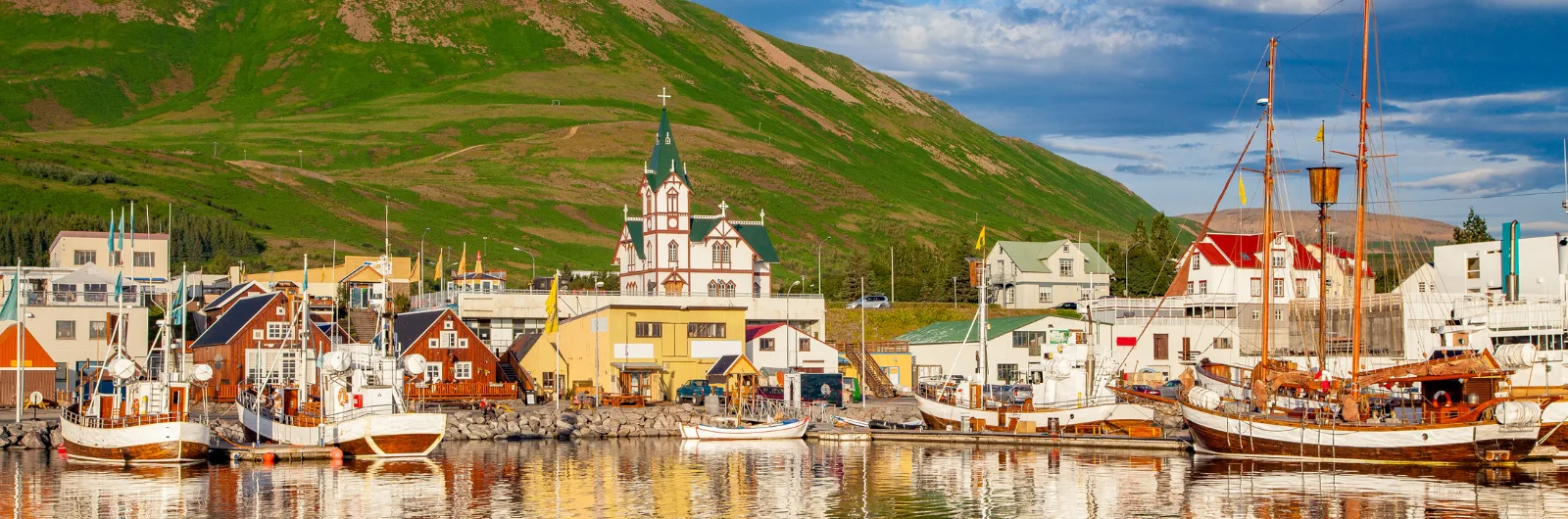
Isafjordur: capital at the edge of the world
Isafjordur is the largest settlement in the Westfjords, with around twenty-six hundred inhabitants. It is wedged onto a sand spit that juts into the Skutulsfjordur, surrounded by mountains that enclose and shelter it. It is a town that exists because the sea provided enough fish to sustain a community for centuries, and that survives because it has partly reinvented itself around tourism, education, and culture.
The town has a trading history dating back to the sixteenth century, when Danish merchants established a trading post. The oldest buildings in the centre — the wooden houses by the harbour, some from the eighteenth century — are among Iceland’s oldest and today house the Westfjords Heritage Museum. The architecture of Isafjordur is modest and functional: corrugated iron houses painted in vivid colours against the grey of the sky and the mountains.
The food scene is surprisingly good for a town of this size. Tjoruhusid, a fish restaurant in a former warehouse by the harbour, serves buffets of fresh fish caught that day, among the best meals you can have in Iceland. There is no fixed menu: they serve whatever came in that morning, prepared in several ways, with bread and butter. It is an experience that connects directly to the fishing economy that sustains the region.
From Isafjordur, boat trips to Hornstrandir depart, kayaking excursions between fjords are organised, and mountain trails offer views that reward the effort of getting here. The town also hosts the annual music festival Aldrei for eg sudur (“I never went south”), a name that perfectly captures the attitude of a community that defines itself by its remoteness and does not apologise for it.
Hornstrandir: nature without concessions
North of the Westfjords, accessible only by boat, lies Hornstrandir: a nature reserve with no roads, no permanent inhabitants, no electricity, and no conventional tourist infrastructure. It is the only place in Iceland where the Arctic fox is protected and where its presence is regular and visible. It is, for many, the wildest place in Europe.
Hornstrandir was inhabited until the 1950s, when the last fishing and farming families abandoned the peninsula, unable to sustain a viable life in a territory without roads and with extreme weather. The abandoned houses, stone walls, and remnants of the fishing industry remain as testimony to a way of life that modernity rendered unsustainable.
Today, Hornstrandir is a trekking destination for experienced hikers. Boats depart from Isafjordur and Bolungarvik, dropping walkers at remote bays from which multi-day routes begin. There are no serviced huts: you sleep in a tent, carry all your food, and depend entirely on your own planning. Trails are not always clearly marked, and the terrain can include river crossings, steep slopes, and stretches of snow even in July.
The appeal of Hornstrandir is not a specific waterfall or a photographic viewpoint. It is the experience of walking for hours without seeing another person, of encountering an Arctic fox that watches you with curiosity from ten metres away, of camping in a bay where the only sounds are the wind and the seabirds. It is Iceland before Iceland, and it requires a level of preparation and self-reliance that filters out everyone except those genuinely seeking this kind of experience.
Heydalur and the hot springs
The Westfjords have several natural thermal pools, but Heydalur deserves particular mention. Located in an inland valley, Heydalur is a farm converted into rural accommodation with a natural thermal pool fed by a geothermal spring. It is not a designed spa: it is an outdoor pool, surrounded by mountains, where hot water rises directly from the earth.
The farm offers accommodation in simple rooms and also allows camping. It keeps Icelandic horses for rides through the valley and a greenhouse where vegetables are grown using geothermal heat. It is a place that encapsulates the Westfjords’ philosophy: nothing ostentatious, everything authentic, nature as amenity rather than spectacle.
Other thermal baths in the region include the Reykjafjardarlaugpool, a small outdoor pool beside the road in a remote northern fjord, and Pollurinn, a natural hot pool by the sea in Talknafjordur. These are experiences minimal in infrastructure and maximal in context: submerging yourself in hot water while gazing at an Arctic fjord in the rain has a therapeutic quality that no designed spa can replicate.
Depopulation: the human context
The Westfjords have been losing population steadily for over a century. From the nine thousand inhabitants the region had in the mid-twentieth century, around seven thousand remain, scattered across increasingly small villages. Young people leave for Reykjavik or abroad, schools close, services concentrate in Isafjordur, and the cycle reinforces itself.
This depopulation is the reason the Westfjords are the way they are. Roads are not paved because the population does not justify the investment. Services are scarce because there is no critical mass of users. The region remains remote not by aesthetic choice but by demographic and economic reality. Understanding this shifts the traveller’s perspective: what looks like romantic isolation is also structural abandonment, and the people who still live here do so by conscious choice and, often, by stubbornness.
Tourism, paradoxically, is one of the few sources of economic hope. But it must be low-intensity tourism: the region cannot absorb crowds, does not have the infrastructure for them, and does not want to transform into something it is not. The question of how to balance tourist development and preservation of character is one of the most pressing the Westfjords face.
Practical planning
When to go: late June to mid-August. Outside this window, many roads are closed or in precarious condition, and services are drastically reduced. July is the safest month.
How long: a minimum of three days allows you to see Dynjandi, Latrabjarg, and Raudasandur with intensive driving. Four or five days give a more reasonable pace and include Isafjordur and the hot springs. A week allows you to explore the northern fjords, take a day trip to Hornstrandir, and absorb the rhythm of the place.
Vehicle: an SUV or a car with good ground clearance is recommended. You do not legally need a 4x4, but many secondary roads punish low-slung cars. The road to Latrabjarg and the descent to Raudasandur are the most demanding stretches.
Fuel: there are stations in Isafjordur, Thingeyri, Patreksfjordur, Bildudalur, and few other places. Fill up every chance you get. The distances are not enormous, but fuel consumption on gravel and hills is higher than expected.
Accommodation: supply is limited. Booking ahead in summer is essential for guesthouses and hotels. Campsites are the flexible alternative: there are sites in Isafjordur, Thingeyri, Patreksfjordur, Brjanslaekur, and beside Dynjandi.
Mobile coverage: patchy outside the towns. On many roads and at Latrabjarg there is no signal. Download offline maps and do not depend on your phone for navigation in remote areas.
Suggested route: if coming from the south, take the ferry from Stykkisholmur to Brjanslaekur. From Brjanslaekur, drive to Raudasandur and Latrabjarg (one night in Patreksfjordur or Breidavik). The next day, head north to Dynjandi (a long stop) and continue to Thingeyri or Isafjordur. Spend a day exploring Isafjordur and surroundings. Return via Route 61 towards Holmavik and rejoin the Ring Road, or cross north through Strandir if time allows.
The Westfjords are not an add-on to a trip around Iceland: they are a statement of intent. Going there means accepting that the road will not be comfortable, that services will be minimal, that the landscape will not be packaged for quick consumption. It also means finding an Iceland that the Ring Road does not show and that social media barely captures: slower, harder, more honest. The reward is not in a photograph but in the certainty of having reached a place that does not make arrival easy, and that for precisely this reason has preserved what other places have lost.
More on Iceland
Keep reading.
Other pieces from the same destination.

Next step
Ready for Iceland?
The guide is for travelling.
Offline maps, itineraries and everything that doesn't fit in an article.
Get the Iceland guide