
Greece · 28 July 2026
Cephalonia: the big island that isn't in a hurry
Cephalonia is the largest Ionian island and the one with the most unhurried tourism profile: Robola wine, the Myrtos beach viewed from above, the underground Lake Melissani.

Lake Melissani was discovered accidentally in 1951, when a karst ceiling above it partially collapsed and left an opening to the sky. Below the hole, in the darkness of the cave, was a lake of turquoise water with visibility of several metres. What was not immediately clear was why a lake inside an island in the Mediterranean had such spectacular clarity and a faint saltiness. The answer arrived with later geological investigation: seawater enters Cephalonia’s subterranean karst system on the island’s west coast, travels several kilometres underground, and emerges in Lake Melissani. The journey takes approximately fourteen days.
This geological anomaly summarises quite well what makes Cephalonia distinctive among the Ionian Islands: there is more here than initially meets the eye, and understanding it requires a degree of effort and curiosity.
The largest and least hurried island
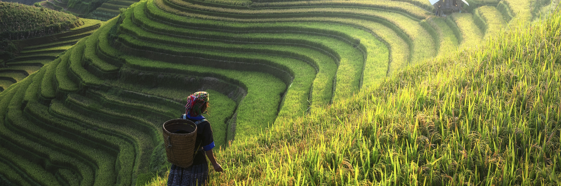
Cephalonia — also spelled Kefalonia, the transliteration of the Greek — covers 781 square kilometres and is the largest of the Ionian Islands. Unlike Corfu (more developed) or Zakynthos (more festive), Cephalonia has its own pace, slower and more deliberate. The territory is mountainous — Mount Ainos, in the centre, reaches 1,628 metres — and the coastline is fragmented into peninsulas and inlets that make road journeys longer than the map suggests.
This geographical character shapes the island’s tourism profile. There is no single hub concentrating all activity: the capital, Argostoli, is in the west; the best beaches are in the north and west; the wine country is on the slopes of Ainos; the quietest beaches are in the east and south. Doing the island justice requires choosing a base and moving by car. This naturally filters for a kind of traveller not in pursuit of a nightlife destination or a mass beach resort.
Myrtos: the view and the reality
Myrtos beach is the most photographed in the Ionian Islands and one of the most photographed in Greece. The angle used in almost every photograph — from the clifftop viewpoint looking down over the curve of white pebbles between three-hundred-metre cliffs, with the water shading from turquoise to deep blue — is genuinely one of the finest landscapes in the Mediterranean.
What is worth knowing before descending to the beach: Myrtos faces north and has almost constant swell. The water is not especially calm for swimming with small children. The stones and pebbles are large, and there is no natural shade — only hired umbrellas. In July and August the car parks fill before ten in the morning and you must leave the car on the road verge and walk down. None of this makes it a bad beach: the water is extraordinary and the landscape from below is still spectacular. But the gap between the clifftop photograph and the experience of being on the beach is large enough to be worth mentioning.
The Myrtos viewpoint, a few kilometres before the beach turn-off climbing from Agios Kirikis, is where the classic image exists. There is a small car park and a viewing terrace. At eight in the morning it is empty. By eleven there is a queue for photographs.
Robola wine and Mount Ainos
The most representative wine of Cephalonia is Robola, a white made from the indigenous grape variety of the same name grown on the slopes of Mount Ainos between 400 and 800 metres altitude. Robola has bright acidity, citrus and mineral notes, and a light texture that makes it the ideal match for the fish and seafood of local tavernas. The Robola Wine Cooperative, based in the village of Fragata, produces the best-known version. Family wineries in the hillside villages of Travliata and Peratata make wines that never leave the island.
Mount Ainos holds the world’s only forest of Abies cephalonica — the Greek fir, a species named after the island — growing on the upper slopes and creating a landscape completely different from the coast below. The Ainos National Park is accessible by road, though the summit requires about two kilometres on foot from the end of the tarmac. On clear days the view from the top encompasses the Ionian Islands, the Peloponnese and the Gulf of Patras.
Argostoli and the tidal phenomenon
The island’s capital has a particularity that surprises those who arrive without knowing: the Katavothres tidal mills at the northern end of the Argostoli lagoon — an inland saltwater lagoon connected to the sea — where seawater cascades into the island’s karst system. The phenomenon was documented by nineteenth-century scientists but fully explained only in the 1960s, when dye injected at the Katavothres reappeared fourteen days later in Lake Melissani. The sea enters from the west and emerges, purified and slightly desalinated, in the east.
The Drapanos bridge crossing the lagoon was built by the British during the Ionian Islands protectorate: at the time of its construction in 1813 it was the longest bridge in Greece. It is still in use, though traffic is limited to one lane.
The 1953 earthquake destroyed 80% of Cephalonia’s buildings. The Argostoli visible today is an almost complete reconstruction, executed with varying degrees of elegance depending on the neighbourhood and the decade. It lacks the accumulated personality of centuries that Corfu has, but it functions as a city: market, cafes in Vallianou Square, tavernas at the harbour. Local life here is not constructed for tourism.
The complete Far Guides Greece guide includes detailed routes across the mainland and islands, interactive maps and all the practical information you need to plan your independent trip.
More on Greece
Keep reading.
Other pieces from the same destination.


Next step
Ready for Greece?
The guide is for travelling.
Offline maps, itineraries and everything that doesn't fit in an article.
Get the Greece guide