Montenegro
The smallest country on the Adriatic: why it deserves more than a day trip from Dubrovnik
Montenegro fits in a glance but not in a day. 13,812 square kilometres where the Venetian coast becomes an Orthodox mountain heartland in under an hour, where Europe's deepest canyons open up a short drive from the Adriatic.
- Size 13,812 km² · smaller than Connecticut
- Independence 2006 · 55.5% referendum
- Currency Euro (unilateral, not ECB)
- Minimum trip 5 days · ideal 7-10
A country that fits in a glance but not in a day
Montenegro covers 13,812 square kilometres. Smaller than the state of Connecticut. Smaller than Northern Ireland. Drive from the Croatian border to the Albanian one along the coast and you’ll be there in three hours. Cross from the Adriatic to Serbia through the interior and it takes barely two. Yet within those dimensions lies a country with a density of geography and culture that’s difficult to explain until you’ve travelled through it.
Most visitors arrive in Montenegro by accident: a day trip from Dubrovnik that crosses the border, descends to the Bay of Kotor, takes photographs of still water framed by mountains, buys some lavender, and returns before dinner. Hundreds of coaches do this every day between April and October. What those travellers take home is a postcard — beautiful, yes, but profoundly incomplete.
Because Montenegro is not just the Bay of Kotor. It is a country where the Venetian coast becomes an Orthodox mountain heartland in under an hour’s drive. Where an Ottoman town and a nineteenth-century royal capital coexist thirty kilometres apart. Where the deepest canyons in Europe open up just a short distance from beaches that recall southern Italy. The name says it all: Crna Gora — Black Mountain. A country defined not by its coastline — which is spectacular — but by what rises behind it.
Why Montenegro exists where it does
To understand this country you need to understand its geography, and its geography begins with an anomaly. The Bay of Kotor — Boka Kotorska — is not a bay in any conventional sense. It is a submerged river valley, the result of a river that spent millions of years carving a canyon through limestone mountains until the Adriatic flooded it at the end of the last ice age. The result is what looks like a Mediterranean fjord: saltwater reaching more than twenty kilometres inland, surrounded by vertical walls that exceed a thousand metres.
That geological formation determined everything else. Kotor, at the innermost point of the bay, became a perfect natural harbour — sheltered from waves, invisible from the open sea, easy to defend. The Illyrians understood this. The Romans understood this. Venice understood it so well that it governed the bay for nearly four centuries, leaving in its stone a legacy that still defines the visual identity of the Montenegrin coast: bell towers, palaces, loggias, coats of arms carved into lintels.
But a few kilometres from the coast, the terrain changes radically. Mount Lovćen rises to 1,749 metres directly from sea level. There is no gradual transition: the Adriatic ends and the Dinaric Alps begin. That physical barrier created two worlds. The littoral, open to maritime trade, looked towards Venice and the Mediterranean. The interior, isolated and vertical, built its own identity around Orthodox monasteries, warrior clans, and a fierce resistance to any invader — Ottoman, Austrian, or otherwise.
That duality between coast and interior, between Latin influence and Orthodox Slavic tradition, remains the founding tension of Montenegro. You can sense it in the architecture, the cuisine, the accents, the way people respond when you ask where they’re from. This is not a country with a single, sealed identity: it is a country where several identities coexist, sometimes comfortably, sometimes with friction.
Four regions, four worlds
Venetian legacy
Open to maritime trade, looked towards Venice and the Mediterranean. White stone, terracotta roofs, slender bell towers, coats of arms on lintels. Kotor, Perast, Herceg Novi, Budva: four centuries of the Republic of Saint Mark written into the architectural grammar.
Orthodox tradition
Isolated and vertical, built its identity around Orthodox monasteries, warrior clans and fierce resistance to every invader. Cetinje royal capital until 1918, Podgorica functional and socialist. The Lovćen barrier (1,749 m) separates two worlds 25 km apart.
The Venetian coast
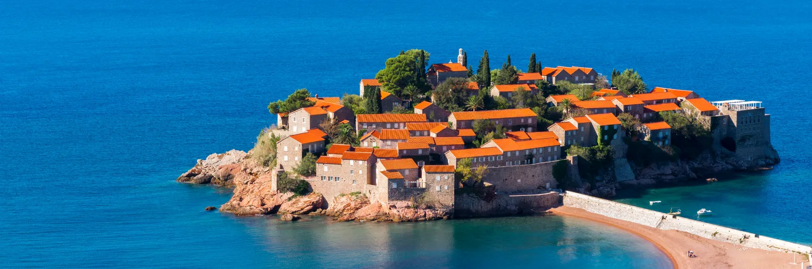
From Herceg Novi to Budva, the Montenegrin littoral is essentially a legacy of the Republic of Venice. The walled towns of Kotor, Perast and Herceg Novi share a recognisable architectural grammar: white stone, terracotta roofs, churches with slender bell towers, narrow streets climbing toward hillside fortifications. Kotor is the centrepiece, a UNESCO World Heritage Site since 1979, but Perast has an intimacy that Kotor lost long ago with the arrival of cruise ships. And Herceg Novi, at the mouth of the bay, offers something the other two do not: the character of a real town, with markets, pharmacies, neighbours walking down to buy bread.
South of the bay, Budva and Sveti Stefan represent a different register: the tourist coast, with sand and pebble beaches, luxury hotels, and a nightlife that draws half of Belgrade every summer. It is not deep Montenegro, but it has its own logic and its own appeal when visited outside peak season.
The Orthodox interior
Cetinje, the former royal capital, lies just 25 kilometres from Kotor but a world away. Here there are no Venetian palaces but Orthodox monasteries, nineteenth-century embassies converted into museums, and a provincial dignity reminiscent of small European capitals that ceased to be capitals. Cetinje was the heart of the Kingdom of Montenegro until 1918, and that memory is present on every corner.
Further east, Podgorica — the current administrative capital — makes no pretence of being beautiful. It is a functional city, rebuilt after the bombings of the Second World War, with socialist-era blocks and an urban energy that has nothing to do with the coast. But it is the connection point to the interior: from here you can reach Lake Skadar, the largest nature reserve in the Balkans, and the roads that climb towards the mountainous north.
The Ottoman south
Ulcinj, Montenegro’s southernmost city, was Ottoman for three centuries and today has a predominantly Albanian and Muslim population. Its old town, perched on a headland above the sea, has more in common with the cities of northern Albania than with Kotor or Budva. Here minarets replace bell towers, the cuisine incorporates spices you will not find elsewhere in the country, and the Long Beach — Velika Plaža — stretches thirteen kilometres to the Albanian border. It is the Montenegro that most guidebooks barely mention, and one of the most interesting stretches of the entire eastern Adriatic.
The mountainous north
Durmitor is the other Montenegro. A mountain massif exceeding 2,500 metres, with 18 glacial lakes, forests of black pine that give the country its name, and the Tara River Canyon — 1,300 metres deep, the deepest in Europe after the Vikos Gorge in Greece. Here there is no Venetian or Ottoman influence: there are shepherds, mountain refuges, bridges from the Yugoslav era, and a sense of isolation that is hard to believe exists three hours from the coast.
Durmitor National Park is a UNESCO World Heritage Site, and the bridge over the Tara — the Đurđevića Tara Bridge, built in 1940 and partially destroyed during the Second World War — is one of the most striking structures in the Balkans. Not for its size, but for where it was built: a concrete arch suspended 172 metres above the river, between rock walls cloaked in forest.
A country born in 2006
Montenegro is one of the youngest nations in Europe. It declared independence from Serbia in June 2006 through a referendum won by 55.5% of voters — barely half a percentage point above the required threshold. That figure says a great deal about the country’s identity politics: nearly half the population voted to remain in union with Serbia. The fault lines have not disappeared. They persist in politics, in debates over language (Montenegrin or Serbian?), in the relationship with the Serbian Orthodox Church.
Today Montenegro is a candidate for European Union membership and has been a NATO member since 2017. It uses the euro as its de facto currency — a unilateral decision, not an agreement with the ECB — which simplifies life for the traveller enormously. The economy depends heavily on coastal tourism and foreign property investment, with all the benefits and complications that entails. The coast has transformed at dizzying speed over the past two decades: where there were once fishing villages, there are now hotel complexes. But the interior remains another country — slow, inexpensive, empty in the best sense of the word.
How many days and at what pace
The most common mistake is treating Montenegro as an add-on: two nights in Kotor tacked onto a Croatia trip. That will give you the bay and little else. If you want to understand the country — coast, interior, mountains — you need a minimum of five full days. With seven or eight you can cover all four regions without rushing. With ten or twelve, you can afford the luxury of spending two nights in places that deserve it: Perast, Cetinje, Durmitor, Ulcinj.
The natural rhythm of Montenegro is short distances with radical changes of scenery. From Kotor to Cetinje is 25 kilometres and 25 hairpin bends up the flank of Lovćen: half an hour of driving that takes you from one world to another. From Podgorica to Durmitor is two and a half hours along mountain roads that traverse the Morača Canyon — one of the most spectacular driving stretches in Europe that nobody mentions because it does not appear on any viral list.
The distances are small. The changes are enormous. That is Montenegro’s paradox and, at the same time, its greatest virtue as a destination. You do not need weeks, domestic flights, or overnight trains. You need a car, a week, and the willingness to look beyond the bay.
This guide is built for exactly that: to help you understand what is in front of you before you see it, to explain why each place is the way it is, and to ensure that at the end of your trip you take home something more than photographs of turquoise water between mountains.