Iceland
An island between two tectonic plates where geology defines every travel decision
Iceland is not a finished place. It sits on the Mid-Atlantic Ridge, where two tectonic plates pull apart at two centimetres a year, and every landscape is a permanent negotiation between subterranean fire and the ice that covers it.
- Geology Mid-Atlantic Ridge · plates pulling apart 2 cm/year
- Population 380,000 · two-thirds in greater Reykjavik
- Ring Road 1,300 km · 10-14 days at a reasonable pace
- Glaciers 11% of land · Vatnajökull, largest in Europe
An Island Still Being Made
That slow, relentless separation of the North American and Eurasian plates is the reason Iceland exists at all. Magma wells up through the gap, solidifying into basalt, building new land in real time. The island is, in geological terms, an infant — around sixteen million years old at its oldest edges, with some coastline measured in decades rather than millennia.
This is not background trivia. It is the single most important fact about travelling here. Geology dictates the roads, the settlements, the economy, the calendar, and the aesthetics of everything you will see. The steaming ground beneath Reykjavik heats the city’s homes. The glacial rivers that carve through the highlands make entire regions impassable except for a few weeks each summer. The volcanic eruptions that periodically close airports or swallow farmland are not anomalies — they are the island functioning as designed.
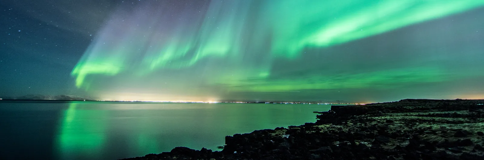
Fire, Ice, and the Space Between
The cliché calls Iceland “the land of fire and ice.” Like most clichés, it persists because it is basically accurate. About eleven per cent of the country is covered by glaciers, including Vatnajökull, the largest ice cap in Europe. Beneath several of those glaciers sit active volcanoes — a combination that produces jökulhlaups, catastrophic glacial floods triggered by subglacial eruptions. The interplay between heat and cold is not poetic metaphor. It is the literal mechanism shaping the landscape.
But fire and ice only describe the extremes. Most of what you will actually encounter falls somewhere between: vast lava fields softened by centuries of moss; geothermal valleys where the earth hisses and bubbles with no drama at all; grey gravel plains that stretch for dozens of kilometres without a single landmark. Iceland’s dominant colour is not white or red. It is a muted palette of greys, greens, and browns, interrupted by the occasional shocking blue of a glacial lagoon or the black of a volcanic sand beach.
Scale and Emptiness
Iceland is roughly the size of Hungary or the US state of Kentucky, but with a population of around 380,000 — two-thirds of whom live in the greater Reykjavik area. Step outside the capital region and the emptiness becomes the defining feature of your journey. In the Westfjords, you may drive for an hour without passing another car. In the interior highlands, roads dissolve into unmarked tracks across black desert where the only navigation aids are occasional cairns left by previous centuries of travellers.
This emptiness is not accidental. Much of Iceland is simply uninhabitable. The interior is a volcanic desert at altitude, scoured by wind, lacking soil, water infrastructure, or shelter. Historically, Icelanders clung to the coast and the handful of fertile valleys, and that pattern holds today. The Ring Road — Route 1, completed only in 1974 — circles the island’s perimeter, connecting the towns and farms that hug the shore. Almost everything you visit will be within an hour of that single road.
How to Travel Here
Iceland is overwhelmingly a driving destination. Public transport outside Reykjavik is minimal, and even the bus services that exist are seasonal and infrequent. Most travellers rent a car and follow the Ring Road, either entirely (roughly 1,300 kilometres) or in sections. The full circuit takes a minimum of seven days at a reasonable pace, though ten to fourteen allows for detours and weather delays.
Weather delays are not hypothetical. Icelandic weather is volatile even by North Atlantic standards. A clear morning can become a horizontal rain squall within an hour, and wind speeds regularly exceed what most drivers have ever experienced. In winter, roads close without warning. In summer, the twenty-plus hours of daylight distort your sense of time and make it easy to drive far more than you intended.
The F-roads — highland tracks requiring four-wheel drive and river crossings — open only in late June or July and close again by September. They access some of Iceland’s most extraordinary landscapes, including Landmannalaugar and Askja, but they demand preparation, experience, and a suitable vehicle. This guide will note where F-roads are required and where a standard car suffices.
What This Guide Covers
This guide follows a geographic logic. After the history that shaped Iceland’s identity, we move through the country region by region: Reykjavik and its surroundings, the Golden Circle, the South Coast, the Westfjords, and the North. The final sections will cover practical information — driving, costs, seasons, and the logistics that make or break an Icelandic trip.
Each section combines route guidance with the context that makes the landscape legible. Iceland rewards travellers who understand what they are looking at — why the columnar basalt at Reynisfjara formed in hexagonal pillars, why the Althing was placed at Þingvellir, why the turf houses of the north were built that way for a thousand years. This guide is built for that kind of traveller: someone who wants not just to see Iceland, but to read it.
The island does not require extreme fitness or specialist equipment for most routes. It does require patience, flexibility, and a willingness to let the weather and the road dictate the day’s plan. Iceland is not a place you conquer. It is a place you negotiate with.